
Table of Contents
The Islands: Relevance
- GS 1: Distribution of key natural resources across the world
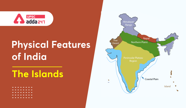
Physical Features of India
- India’s physical features can majorly be divided into 6 parts:
- The Northern and North-eastern Mountains
- The Northern Plain
- The Peninsular Plateau
- The Indian Desert
- The Coastal Plains
- The Islands.
- We have already dealt with Himalayas, Northern Plains, Peninsular Plateau, The Coastal Plains of India and The Indian Desert comprehensively. In this article, we will discuss about The Islands.
The islands
- There are two major island groups in India – one, Andaman and Nicobar Archipelago in the Bay of Bengal and the other, Lakshadweep islands in the Arabian Sea.
- Other than the above two groups, there are islands in Indo-Gangetic Delta, which are more a part of delta than islands; and between India and Sri Lanka, which are remnants of Adams Bridge or Rama Setu; formed due to submergence.

Andaman and Nicobar Islands
- Andaman and Nicobar Islands were formed due to collision between Indian Plate and Burma Plate.
- They are the southward extension of Arakan Yoma range in Myanmar, which in itself is an extension of Purvanchal Hills.
- These are situated roughly between 6°N-14°N and 92°E -94°E.
- The two principal groups of islets include the Ritchie’s archipelago and the Labrynth island.
Andaman islands
- The entire group of islands is divided into three broad categories – North Andaman, Middle Andaman and South Andaman.
- North and South Andaman are separated by a waterbody which is called the Ten degree channel.
- Little Andaman is separated from South Andaman by Duncan Passage.
- Port Blair, the capital of Andaman and Nicobar Islands is located in the South Andaman.
Nicobar Islands
- Great Nicobar is the largest island in the Nicobar Islands. It is very close to Sumatra Island of Indonesia.
- Here, some smaller islands are volcanic in origin. Barren island, the only active volcano in India is situated in the Nicobar Islands.

Lakshadweep Islands
- There are three types of islands n the Arabian Sea: Amindivi Islands, Laccadive Islands, and Minicoy Island.
- The above islands are collectively known as Lakshadweep Islands.
- The entire island group is built of coral deposits.
- These islands are a part Reunion Hotspot volcanism.
- These islands receive convectional rainfall and have an equatorial type of vegetation.
- These are widely scattered between 8°N-12°N and 71°E -74°E longitude.
- These islands are located at a distance of 280 km-480 km off the Kerala coast.
- There are approximately 36 islands of which 11 are inhabited.
- Minicoy is the largest island with an area of 453 sq. km.
- The entire group of islands is broadly divided by the Ten degree channel, north of which is the Amini Island and to the south of the Canannore Island.
- Most of the islands have low elevation and do not rise more than five metre above the sea level.
- The Islands of this archipelago have storm beaches consisting of unconsolidated pebbles, shingles, cobbles and boulders on the eastern seaboard.
- Moreover, the topography of these islands is flat, so relief features such as hills, streams, valleys, etc. are absent.
Also Read:


 TSPSC Group 1 Question Paper 2024, Downl...
 TSPSC Group 1 Answer key 2024 Out, Downl...
 UPSC Prelims 2024 Question Paper, Downlo...
