
Table of Contents
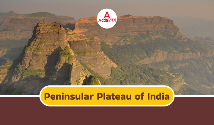
The Peninsular Plateau of India is a vast and ancient landmass forming a significant portion of the southern half of the country. Composed primarily of igneous and metamorphic rocks, it boasts an average elevation of 600 meters. This geological marvel is further distinguished by two major divisions: the Deccan Plateau and the Central Highlands.
Renowned for its mineral resources, scenic hills, and fertile plains, the Peninsular Plateau is the true backbone of India’s geography. Candidates must familiarise themselves with India’s geographical traits is crucial for UPSC civil services examination preparation.
Plateau
A plateau is a raised land area with a flat surface on top, often isolated with no adjacent similar terrain. National Geographic defines plateaus as elevated landforms that sharply rise above their surroundings on at least one side. Typically, plateaus form when underground magma attempts to breach the Earth’s surface but fails to break through the crust. Consequently, this magma gradually uplifts extensive, sturdy rock layers, shaping the plateau over millions of years.
Types of Plateau of India
India is a land of diverse landscapes, and plateaus are a major part of its geography. These elevated, flat areas of land offer scenic beauty, mineral resources, and unique ecosystems. Here’s a look at the major types of plateaus found in India:
Deccan Plateau:
- The Deccan Plateau is the largest and most prominent plateau in India.
- It covers a large portion of southern India, spanning eight states – Maharashtra, Telangana, Andhra Pradesh, Karnataka, Kerala, Tamil Nadu, parts of Odisha and Madhya Pradesh.
- The Deccan Plateau is a volcanic plateau, formed by Deccan Traps – massive lava flows that erupted millions of years ago.
- The plateau has an average elevation of around 600 meters and is bordered by the Western Ghats on the western side and the Eastern Ghats on the eastern side.
Central Highlands:
- The Central Highlands lie north of the Deccan Plateau, covering parts of Madhya Pradesh, Maharashtra, Chhattisgarh, and Rajasthan.
- This region is a complex of plateaus and hills formed by the erosion of ancient rocks.
- The Central Highlands are known for their mineral-rich reserves, including iron ore, manganese, and bauxite.
Chota Nagpur Plateau:
- The Chota Nagpur Plateau is located in eastern India, covering parts of Jharkhand, Odisha, and Chhattisgarh.
- Formed by the Gondwana Landmass millions of years ago, this plateau is rich in mineral resources, including coal, iron ore, copper, and mica.
- The Chota Nagpur Plateau is also home to several tribal communities that have preserved their unique culture and traditions.
Bundelkhand Upland: - The Bundelkhand Upland is situated in central India, bordering Uttar Pradesh and Madhya Pradesh.
- This plateau is known for its rugged terrain and sandstone formations.
- The Bundelkhand Upland is a relatively less elevated plateau compared to others on this list.
Meghalaya Plateau:
- The Meghalaya Plateau is located in northeastern India, in the state of Meghalaya.
- This plateau is known for its heavy rainfall and is home to Cherrapunji, one of the wettest places on Earth.
- The Meghalaya Plateau is a part of the Shillong Plateau, which extends into Bangladesh. The plateau is known for its scenic beauty, waterfalls, and caves.
Marwar Plateau:
- The Marwar Plateau is located in the western part of Rajasthan state.
- This plateau is formed by hard rock formations and is known for its arid climate and desert landscape.
- The Thar Desert, one of the largest deserts in the world, covers a significant portion of the Marwar Plateau.
Malwa Plateau:
- The Malwa Plateau is situated in central India, in the state of Madhya Pradesh.
- This plateau is a fertile region known for its agricultural production.
- The Malwa Plateau is bounded by the Vindhya Range to the north and the Satpura Range to the south.
These plateaus are significant in India’s geography, ecology, and mineral wealth. They provide habitats for diverse flora and fauna, offer scenic landscapes, and hold immense potential for development.
Location of Plateau
Plateaus are present in the following regions. Check the location mentioned below:
- Mountainous terrains
- Arid desert landscapes
- Beneath the oceans
Causes of Plateau Formation
Plateaus form due to various factors, including:
- Thermal Expansion: Plateaus such as the Yellowstone Plateau in the United States, the Massif Central in France, and the Ethiopian Plateau in Africa are examples of the thermal expansion of the lithosphere.
- Crustal Shortening: Plateaus found in regions like North Africa, Turkey, Iran, and Tibet are formed by the thrusting or sliding of crustal blocks over one another.
- Volcanism: Plateaus like India’s Peninsular Plateau, the USA’s Columbia Plateau, and Canada’s Shield are formed by flood basalts resulting from volcanic activity.
Decca Plateau
The Deccan Plateau, a massive volcanic tableland in southern India, boasts an ancient history tied to the breakup of Gondwana. Formed from solidified lava flows, the Deccan Traps, this plateau is rich in minerals and supports diverse ecosystems thanks to the flanking Eastern and Western Ghats. With its laterite soil suitable for agriculture and its rivers draining the land, the Deccan Plateau is a key contributor to India’s geology, resources, and agricultural potential.
The Deccan Plateau is the largest in India. The Deccan Plateau is a triangular landmass that lies to the south of the river Narmada. The Satpura range flanks its broad base in the north while the Mahadev, the Kaimur hills and the Maikal range form its eastern extensions.
Peninsular Plateau of India
The Peninsular Plateau is a raised landmass characterized by ancient crystalline, igneous, and metamorphic rocks. Its formation is linked to the fragmentation of Gondwana land. Key attributes of the Indian Peninsular Plateau include broad, shallow valleys, and gently sloping hills. It comprises two primary divisions: the Central Highlands of India and the Deccan Plateau. The latter is flanked by the Western and Eastern Ghats. Additionally, the Deccan Trap, a volcanic region with igneous rock formations, is a notable feature of this plateau.
Famous Plateau
Here are some renowned plateaus from around the world:
- Deccan Plateau (India): Spanning across 8 Indian states, it encompasses South India and is bordered by three mountain ranges.
- Chotanagpur Plateau (India): Rich in iron, coal, and manganese deposits.
- Tibetan Plateau (China): The largest and highest plateau globally.
- Katanga Plateau (Congo): Known for its abundant copper mines.
- East African Plateau: Notable for its mining of gold and diamonds.
Formation of Peninsular Plateau of India
Candidates can read here about the formation of the Peninsular Plateau of India:
- Formed millions of years ago due to the breakup of the Gondwana supercontinent.
- Composed primarily of igneous and metamorphic rocks, indicating its volcanic origins and immense age.
- The Deccan Traps, a region within the plateau, are specifically formed from solidified lava flows.
Features of Peninsular Plateau of India
Candidates can read here about the features of the Peninsular Plateau of India:
- Central Highlands: The northern part of the plateau, with an average elevation of 600 meters.
- Deccan Plateau: The southern part, is bordered by the Eastern and Western Ghats mountain ranges.
- Broad and shallow valleys with rounded hills characterize the plateau’s topography.
- Prominent rivers like the Godavari, Krishna, Kaveri, and Narmada flow through the plateau, draining the land.

 Longest River in India, Check Top 10 Lon...
 Namdapha National Park - Tiger Reserve, ...
 India Neutrino Observatory (INO)-Types o...
