
Table of Contents
Tectonic plates UPSC: Relevance
- GS 1: Important Geophysical phenomena such as earthquakes, Tsunami, Volcanic activity, cyclone etc.,
Tectonic plates movement: Context
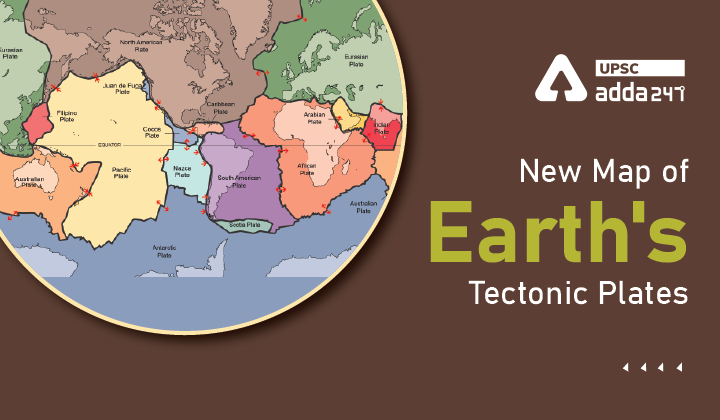
- Recently, researchers from Australia have carried out a new study that included an updated map of the earth’s tectonic plates.
- These materials will help in forming a better understanding of natural hazards like earthquakes and volcanoes.
Tectonic plates of earth: Key points
- The last time the tectonic plate model was updated was in 2003.
- The new study added several new microplates to the existing tectonic plate model like the Macquarie microplate which sits south of Tasmania and the Capricorn microplate that separates the Indian and Australian plates.
- The plate model can be used to evaluate risks from natural hazards; the province model can be used for further exploration of minerals and the orogeny model for a better understanding of the evolution of the earth.
Tectonic plates definition?
- Tectonic plates meaning: A tectonic plate is a massive, irregularly shaped slab of solid rock, made up of lithosphere or the earth’s top layer.
- Tectonic plate movements often lead to earthquakes and volcanoes.
What is Vaalbara?
- The study, titled New maps of global geological provinces and tectonic plates, delved into the past construction of continents like the first supercontinent, Vaalbara.
- Vaalbara fragmented to form other supercontinents over the years, the last being Pangea, which existed some 335-65 million years ago.
- Pangea again gave way to the seven modern continents which make the earth’s land surface today.
New Map of Earth’s Tectonic Plates: Key findings
- The new model for tectonic plates better explains the spatial distribution of 90 per cent of earthquakes and 80 per cent of volcanoes from the past two million years whereas existing models only capture 65 per cent of earthquakes.
- There are 26 orogenies— the process of mountain formation — that have left an imprint on the present-day architecture of the crust. Many of these, but not all, are related to the formation of supercontinents.
- The newly delineated boundary is much wider, approximately 1,500 km, than the previously drawn narrow zone.
- The other large change is in central Asia. The new model now includes all the deformation zones north of India as the plate bulldozes its way into Eurasia.
Read current affairs for UPSC

 TSPSC Group 1 Question Paper 2024, Downl...
 TSPSC Group 1 Answer key 2024 Out, Downl...
 UPSC Prelims 2024 Question Paper, Downlo...
