
Table of Contents
Drainage patterns form an important section of UPSC syllabus. It is one of the most important topics of Indian Geography and aspirants can expect questions from this section in both UPSC Prelims and UPSC Mains. In this article, we will discuss all the important drainage patterns of India that an aspirant must understand comprehensively to have a better grasp over this topic.
What is drainage System?
- In geomorphology, drainage systems are the patterns formed by the streams, rivers, and lakes in a particular drainage basin.
- Alternatively, drainage is referred as the flow of water through a well-defined channel, and drainage system is the network of such channels
What is drainage pattern?
- Drainage pattern is the pattern formed by the streams, rivers, and lakes in a particular drainage basin.
- The drainage pattern of a river depends upon the factors like the topography of the land, whether a particular region is dominated by hard or soft rocks, velocity of water, among others.
Types of drainage patterns
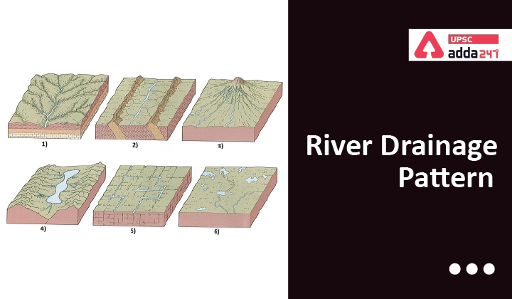
Dendritic drainage pattern
- It is the most common form of drainage pattern.
- One of the distinctive features of this pattern is that it looks like the branching pattern of tree roots.
- Dendritic pattern develops in regions that are covered by homogeneous material.
- Tributaries joining larger streams at acute angle (less than 90 degrees).
- Examples: Indus, Godavari, Mahanadi, Cauvery, Krishna.

Trellis Drainage Pattern
- This type of pattern, as the name suggests, looks like common garden trellis.
- It develops in folded topography where hard and soft rocks exist parallel to each other, similar to those found in the Appalachian Mountains of North America.
- Down-turned folds called synclines form valleys in which resides the main channel of the stream.
- In these types of patterns, short tributary streams enter the main channel at sharp angles as they run down sides of parallel ridges called anticlines.
- Tributaries join the main stream at nearly right angles.
- Examples: The old folded mountains of the Singhbhum (Chotanagpur Plateau).
Parallel drainage pattern
- Parallel drainage patterns develop in regions of parallel, elongate landforms, and where there is a pronounced slope to the surface.
- Tributary streams tend to stretch out in a parallel-like fashion following the slope of the surface.
- A parallel pattern indicates the presence of a major fault that cuts across an area of steeply folded bedrock.
- All forms of transitions can occur between parallel, dendritic, and trellis patterns.
- Example: Most of the rivers originating in the Western Ghats; Godavari, Kaveri, and Krishna.
Rectangular Drainage Pattern
- This type of pattern is mostly found in regions that have undergone faulting.
- Streams, in these types of patterns, follow the path of least resistance and thus are concentrated in places were rocks exposed are the weakest.
- Movement of the surface due to faulting off-sets the direction of the stream.
- Due to this reason, the tributary streams make sharp bends and enter the main stream at high angles.
- Example: Chambal, Betwa and Ken.

Radial (Centrifugal) Drainage Pattern
- It develops around a central elevated point.
- This type of pattern is common to such conically shaped features as volcanoes.
- It forms in areas, where the rivers originate from a hill and flow in all directions.
- Examples: The rivers originating from the Amarkantak range; Narmada and Son rivers.
Centripetal Drainage Pattern
- The centripetal drainage pattern is just the opposite of the radial drainage pattern as streams flow toward a central depression unlike radial where rivers develop around a central elevated point.
- During wetter portions of the year, these streams feed ephemeral lakes, which evaporate away during dry periods.
- Generally, salt flats are created in these dry lake beds as salt dissolved in the lake water precipitates out of solution and is left behind when the water evaporates away.
- Example: Loktak lake in Manipur.
Also Read:


 TSPSC Group 1 Question Paper 2024, Downl...
 TSPSC Group 1 Answer key 2024 Out, Downl...
 UPSC Prelims 2024 Question Paper, Downlo...
