
Table of Contents
Geospatial Energy Map of India- Relevance for UPSC Exam
- GS Paper 2: Governance, Administration and Challenges-
- E-governance- applications, models, successes, limitations, and potential.
- GS Paper 3: Indian Economy- Infrastructure- Energy, Ports, Roads, Airports, Railways etc.

Geospatial Energy Map of India- Context
- Recently, the Geospatial Energy Map of India was launched by National Institution for Transforming India (NITI Aayog).
FSSAI’s State Food Safety Index 2021
Geospatial Energy Map of India- Key Points
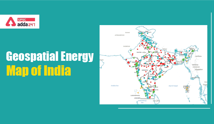
- Development of Geospatial Energy Map of India: NITI Aayog in collaboration with the Indian Space Research Organisation (ISRO) has developed a comprehensive Geographic Information System (GIS) Energy Map of India with the support of Energy Ministries of the Government of India.
- About Geospatial Energy Map of India: The GIS map provides a holistic picture of all energy resources of the country which enables visualization of energy installations such as
- Conventional power plants, oil and gas wells, petroleum refineries, coal fields and coal blocks,
- District-wise data on renewable energy power plants and renewable energy resource potential, etc. through 27 thematic layers.
Geospatial Energy Map of India- Key Objectives
- Geospatial Energy Map of India is a unique effort aimed at integrating energy data scattered across multiple organizations and presenting it in a consolidated, visually appealing graphical manner.
- The Geospatial Energy Map of India attempts to identify and locate all primary and secondary sources of energy and their transportation/transmission networks to provide a comprehensive view of energy production and distribution in a country.
Climate Induced Migration and Modern Slavery
Geospatial Energy Map of India- Key Features
- Geospatial Energy Map of India leverages the latest advancements in web-GIS technology and open-source software to make it interactive and user-friendly.
- The Geospatial Energy Map of India will be useful in planning and making investment decisions. It will also aid in disaster management using available energy assets.
- GIS mapping of energy assets will be useful for ensuring real-time and integrated planning of the energy sector of India, given its large geographical distribution and interdependence.
- GIS-based mapping of energy assets will be advantageous to all concerned stakeholders and will help in accelerating the policy-making process.
- Geospatial Energy Map of India will bring the fragmented data together that will be a great research instrument.


 TSPSC Group 1 Question Paper 2024, Downl...
 TSPSC Group 1 Answer key 2024 Out, Downl...
 UPSC Prelims 2024 Question Paper, Downlo...
