
Table of Contents
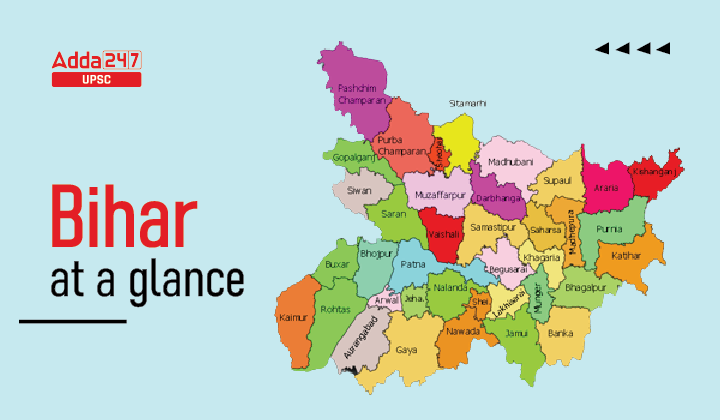
BIHAR AT A GLANCE
| Formation | March 22, 1912 |
| Capital | Patna |
| Population | 10,40,99,452 |
| Area | 94,163 sq. km. |
| Total Districts | 38 |
| High Court | Patna |

Bihar: General Information
- The area of the state is – 94,163 sq. km. (12th largest state in the country).
- State name – Bihar- Due to the abundance of Buddhist monasteries (viharas) in the region.
- State capital – Patna (Ancient name- Pataliputra, Pushppur, Kusumpur and Azimabad.)
- Length from North to South – 345 km.
- Length from East to West – 483 km.
- Geographical location of the state – 24°20’10” to 27°31’15” North Latitude and between 83°19’50” to 88°17’40” East Longitude.
- Bihar was a major center of Buddhism in ancient times.
- Statehood Day (Bihar Diwas) – March 22, 1912.
- States bordering the state – 3 [West Bengal (East), Uttar Pradesh (West) and Jharkhand (South)].
- The country bordering the state – Nepal (in the north).
- Total geographical area (all over India) – 2.86%
- Districts bordering Nepal – 7 [West Champaran, East Champaran, Sitamarhi Madhubani, Supaul, Araria and Kishanganj]
- District bordering Uttar Pradesh – 8 [(Rohtas, Kaimur, Buxar, Bhojpur, Saran, Siwan) Gopalganj and West Champaran]
- Districts bordering West Bengal – 3 [Kishanganj, Purnia and Katihar]
- Districts bordering Jharkhand – 8 [Bhagalpur, Banka, Jamui, Nawada, Gaya, Aurangabad, Rohtas and Katihar]
- District adjoining Bihar’s capital Patna – 9[Arwal, Jehanabad, Nalanda, Lakhisarai, Begusarai, Samastipur, Vaishali, Saran, Bhojpur]
- Largest district in terms of area – West Champaran
- Smallest district in terms of area – Sheohar
- Northernmost District – West Champaran
- Southernmost district – Gaya
- Western most district – Kaimur
- Easternmost District – Kishanganj
- State Climate – Monsoon
- Normal rainfall – 1,205 mm
- Highest rainfall district – Kishanganj
- The district with minimum rainfall – Kaimur.
- The average height above sea level is – 173 feet (about 53 m).
- Total Population of the State according to the Census– 2011– 10,40,99,452.
- Percentage share of total population of India – 8.60%
- Population Density (person/sq.km.) – 1,102
- Most Populated District – Patna
- District with minimum population – Sheikhpura
- District with highest population density – Sheohar
- District with minimum population density – Kaimur (Bhabua)
- Literacy rate (as per 2011, Census) – approximately 61.80% (71.20% male, 51.50% female)
- District with highest per capita income – Patna
- District with minimum per capita income – Sheohar
- District with highest literacy rate – Rohtas
- District with lowest literacy rate – Purnia
- Sex Ratio – 918
- District with highest sex ratio – Gopalganj
- District with lowest sex ratio – Munger
- Child Sex Ratio (0–6 Years) – 935
- District with highest urban population – Patna
- District with minimum urban population – Sheohar
- Percentage of rural population to total population – 88.71%
- Percentage of urban population to total population – 11.29%
- Highest percentage of urban population – Patna
- Minimum percentage of urban population – Samastipur
- Scheduled Castes (SC) – 15.9% of the total population
- District with Highest Scheduled Caste Population – Gaya
- District with highest percentage of SC population – Gaya
- District with minimum scheduled caste population – Sheohar
- District with Minimum Scheduled Caste Population Percentage – Kishanganj
- District with highest percentage of ST population – Katihar
- Districts with minimum percentage of ST population – Sheohar
- of Administrative Divisions – 09 (Koshi, Darbhanga, Saran, Bhagalpur, Patna, Tirhut, Munger, Magadha and Purnia)
- of Districts – 38
- Legislature – Bicameral (upper house – Legislative council, Lower house – Assembly)
- State Symbol – Bodhi tree (located between two swastikas)
- Official language – Hindi
- Second official language – Urdu
- State fish – Mangur
- State anthem – Mere Bharat Ke Kanth har, Tum Ko Shat– Shat Vandan Bihar…
- State Prayer – Meri raftaar pe suraj ki kiran naaz kare…
- Folk dances – Kathghodwa, Chhau, Launda, Dhobia, Jhijhiya, Jharni, Karma and Domkach.
- Major Forest Type – Deciduous.


 TSPSC Group 1 Question Paper 2024, Downl...
 TSPSC Group 1 Answer key 2024 Out, Downl...
 UPSC Prelims 2024 Question Paper, Downlo...
