
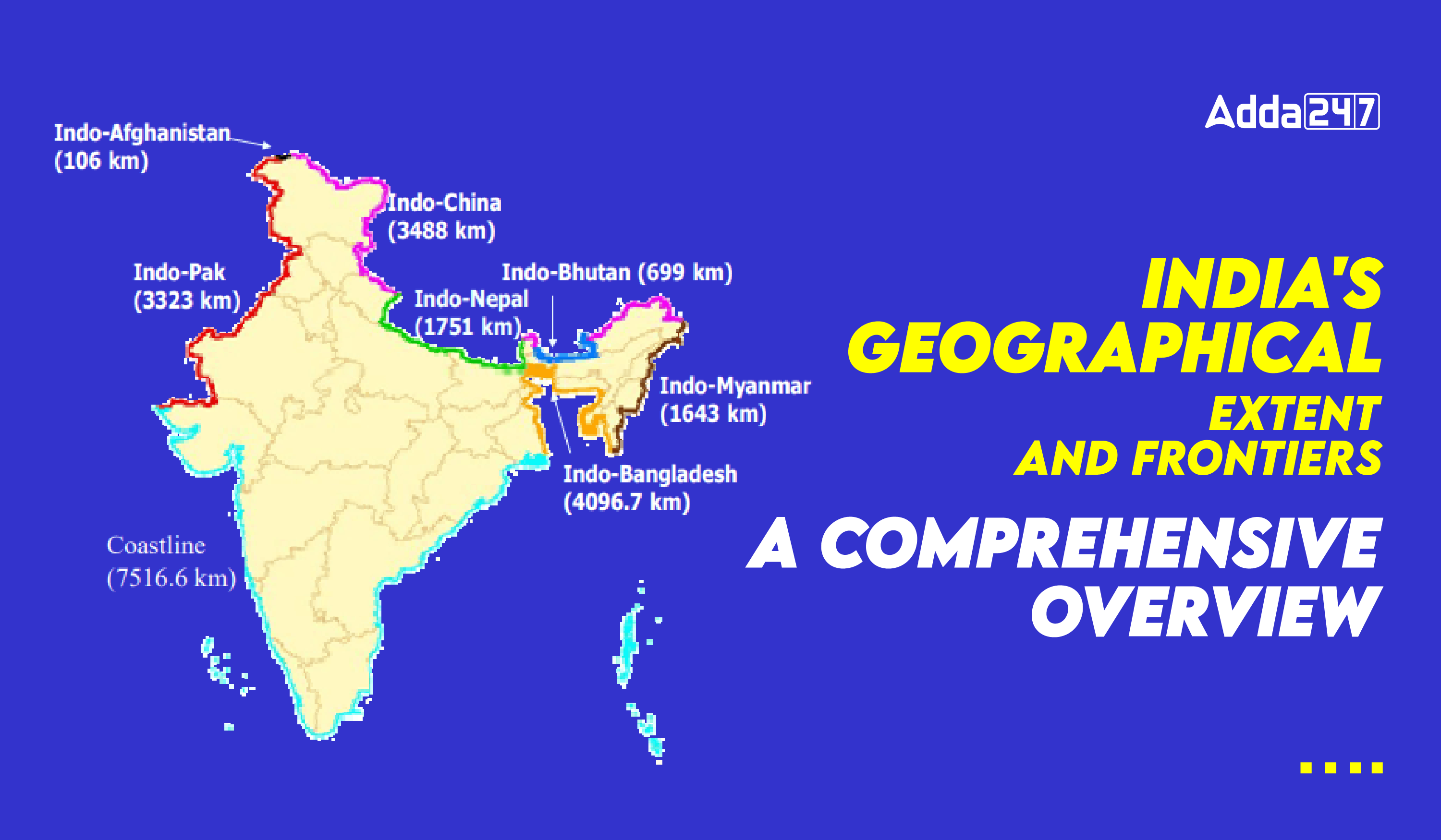
India, the seventh-largest country in the world, is distinguished from the rest of Asia by its unique topographical features sea, and mountains dividing it. Located in the south-central region of the Asian continent, India is a large country spanning across latitudes 8°4’N and 37°6’N and longitudes 68°7’E and 97°25’E. It is the only country in the world wholly located in the northern hemisphere. The land border of India is around 15,200 kilometers, whereas the mainland’s whole coastline, including Andaman and Nicobar and Lakshadweep, is 7,516.6 km long.
India is a vast and diverse country located in South Asia, bordered by several nations and bodies of water. The young fold mountains bordering India’s northwest, north, and northeast. It splits into the Arabian Sea on the west and the Bay of Bengal on the east as it stretches south of roughly 22° north latitude. The landmass stretches for about 30° in both latitudinal and longitudinal directions. The east-west extent seems to be smaller than the north-south extent, notwithstanding this reality.
There is a two-hour time difference between Gujarat to Arunachal. Because of this, the time along the Indian Standard Meridian (82°30’E), which passes through Mirzapur, Uttar Pradesh, is used as the national standard time. Moving northward from the south, the latitudinal extent affects how long day and night last.

Eight states in India are covered by the Tropic of Cancer: Gujarat (Jasdan), Rajasthan (Kalinjarh), Madhya Pradesh (Shajapur), Chhattisgarh (Sonhat), Jharkhand (Lohardaga), West Bengal (Krishnanagar), Tripura (Udaipur), and Mizoram (Champhai).
Here’s a comprehensive overview of its geographical extent and frontiers:
- Borders with Neighboring Countries:
- Pakistan: India shares its northwestern border with Pakistan, demarcated by the Line of Control (LoC) in Jammu and Kashmir and the international border elsewhere.
- China: The northern border of India is with China, delineated by the Line of Actual Control (LAC), which traverses through the Himalayan region.
- Nepal: India’s northern border also extends to Nepal, marked by a shared border that runs across the Himalayas.
- Bhutan: India’s northeastern border touches Bhutan, with close cultural and strategic ties between the two nations.
- Bangladesh: The eastern border of India is with Bangladesh, delineated by the Radcliffe Line, established during the partition of British India in 1947.
- Myanmar: India shares its eastern border with Myanmar, marked by a porous boundary along the states of Arunachal Pradesh, Nagaland, Manipur, and Mizoram.

- Geographical Features:
- Himalayas: India’s northern border is dominated by the towering Himalayan mountain range, which serves as a natural barrier between the Indian subcontinent and Central Asia.
- Gangetic Plain: The vast Gangetic Plain covers much of northern and eastern India, encompassing fertile agricultural land.
- Western Ghats and Eastern Ghats: These mountain ranges flank the western and eastern coasts of India respectively, influencing the climate and biodiversity of the region.
- Deccan Plateau: Central India is characterized by the Deccan Plateau, a vast elevated region with diverse landscapes ranging from forests to semi-arid plains.
- Coastline: India has a long coastline stretching over 7,500 kilometers, bordering the Arabian Sea to the west, the Bay of Bengal to the east, and the Indian Ocean to the south.
- Islands:
- India includes several island territories, the most prominent of which are the Andaman and Nicobar Islands in the Bay of Bengal and the Lakshadweep Islands in the Arabian Sea.
- Political Divisions:
- India is divided into 28 states and 8 Union territories, each with its administrative jurisdiction.
- Strategic Significance:
- India’s geographical location at the crossroads of South Asia, Central Asia, and Southeast Asia gives it strategic importance in regional and global geopolitics.
- The Himalayas act as a natural barrier, but also present challenges and opportunities for India’s security and economic interests, especially in its relations with neighboring countries like China and Pakistan.


 TSPSC Group 1 Question Paper 2024, Downl...
 TSPSC Group 1 Answer key 2024 Out, Downl...
 UPSC Prelims 2024 Question Paper, Downlo...
