
Table of Contents
Latitude and Longitudes- You would have definitely wondered it sometime that how we can locate any place on the planet with pinpoint accuracy? The answer lies in the system of latitudes and longitudes. These imaginary lines creates a grid pattern on the globe, helping us to measure and navigate our world.
In this article, we’ll delve into the basics of latitudes and longitudes, their differences, and their significance in mapping the world. We’ll also examine the specific latitudes and longitudes of India and answer some commonly asked questions.
What are Latitudes and Longitudes?
Latitudes and longitudes are geographical coordinates that are used to determine the location of any point on the Earth’s surface. These coordinates provide a precise location by measuring the distance from the Equator and the Prime Meridian, respectively.
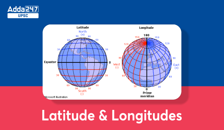
The Equator is an imaginary line that circles the Earth at 0° latitude, while the Prime Meridian is an imaginary line that runs from the North Pole to the South Pole at 0° longitude.
Countries through which equator passes – Ecuador, Colombia, Brazil, Sao Tome & Principe, Gabon, Republic of the Congo, Democratic Republic of the Congo, Uganda, Kenya, Somalia, Maldives, Indonesia and Kiribati, i.e. equator passes through a total of 13 countries.
Together, latitudes and longitudes create a grid system that divides the Earth into imaginary lines that make it easier to locate any point on the Earth’s surface accurately. Latitude is measured in degrees, minutes, and seconds, and it ranges from 0° at the Equator to 90° at the North and South Poles. Longitude is also measured in degrees, minutes, and seconds and ranges from 0° at the Prime Meridian to 180° at the International Date Line.
| UPSC Exam-Related Study Notes | |
| Mauryan Empire |
Chola Dynasty |
| Anglo-Maratha War | 16 Mahajanapadas |
Globe Latitudes and Longitudes
If you want to locate a point on a globe, you need to know its latitudes and longitudes. To do this, you need to use a globe that has the latitudes and longitudes marked on it. You can find such globes at any store that sells educational materials.
When locating a point on a globe, you need to start by finding its latitude. To do this, you need to measure the distance of the point from the Equator. If the point is north of the Equator, it has a positive latitude, while if it is south of the Equator, it has a negative latitude.
Next, you need to find the longitude of the point. To do this, you need to measure the distance of the point from the Prime Meridian. If the point is east of the Prime Meridian, it has a positive longitude, while if it is west of the Prime Meridian, it has a negative longitude.
Countries through which prime meridian passes – UK, France and Spain in Europe, and Algeria, Mali, Burkina Faso, Togo and Ghana in Africa
Latitudes and Longitudes of Indian States
India is located in the northern hemisphere and covers an area of 3.287 million square kilometers. The country is bounded by the Arabian Sea to the west, the Bay of Bengal to the east, and the Indian Ocean to the south. The latitudinal extent of India is between 8° 4′ and 37° 6′ north, while its longitudinal extent is between 68° 7′ and 97° 25′ east.
| State | Latitude | Longitude |
|---|---|---|
| Andhra Pradesh | 15.9129°N | 79.73999°E |
| Arunachal Pradesh | 28.2180°N | 94.7278°E |
| Assam | 26.2006°N | 92.9376°E |
| Bihar | 25.0961°N | 85.3131°E |
| Chhattisgarh | 21.2787°N | 81.8661°E |
| Goa | 15.2993°N | 74.1240°E |
| Gujarat | 22.2587°N | 71.1924°E |
| Haryana | 29.0588°N | 76.0856°E |
| Himachal Pradesh | 31.1048°N | 77.1734°E |
| Jharkhand | 23.6102°N | 85.2799°E |
| Karnataka | 15.3173°N | 75.7139°E |
| Kerala | 10.8505°N | 76.2711°E |
| Madhya Pradesh | 22.9734°N | 78.6569°E |
| Maharashtra | 19.7515°N | 75.7139°E |
| Manipur | 24.6637°N | 93.9063°E |
| Meghalaya | 25.4670°N | 91.3662°E |
| Mizoram | 23.1645°N | 92.9376°E |
| Nagaland | 26.1584°N | 94.5624°E |
| Odisha | 20.9517°N | 85.0985°E |
| Punjab | 31.1471°N | 75.3412°E |
| Rajasthan | 27.0238°N | 74.2179°E |
| Sikkim | 27.5330°N | 88.5122°E |
| Tamil Nadu | 11.1271°N | 78.6569°E |
| Telangana | 18.1124°N | 79.0193°E |
| Tripura | 23.9408°N | 91.9882°E |
| Uttar Pradesh | 26.8467°N | 80.9462°E |
| Uttarakhand | 30.0668°N | 79.0193°E |
| West Bengal | 22.9868°N | 87.8550°E |
Difference btw latitude and longitude
| Latitudes | Longitudes |
|---|---|
| Latitudes are horizontal lines running east-west across the Earth’s surface. | Longitudes are vertical lines running north-south across the Earth’s surface. |
| Latitudes are measured in degrees north or south of the equator, which is defined as 0 degrees latitude. | Longitudes are measured in degrees east or west of the Prime Meridian, which is defined as 0 degrees longitude. |
| The equator is the most well-known line of latitude, located at 0 degrees latitude. | The Prime Meridian is the most well-known line of longitude, located at 0 degrees longitude. |
| The latitudinal measurement ranges from 0 degrees at the equator to 90 degrees at the North and South Poles. | The longitudinal measurement ranges from 0 degrees at the Prime Meridian to 180 degrees at the International Date Line. |
| Latitudes are used to determine the climate and weather patterns of a region. | Longitudes are used to determine time zones around the world. |
| The distance between two lines of latitude is always the same, approximately 111 kilometers or 69 miles. | The distance between two lines of longitude varies depending on the latitude, with the distance being the greatest at the equator and decreasing as you move towards the poles. |
Latitudes and Longitudes Facts for UPSC Aspirants
- Latitudes and longitudes are used to identify the location of any point on the Earth’s surface.
- Latitudes are measured in degrees north or south of the equator, while longitudes are measured in degrees east or west of the Prime Meridian.
- The equator is the most well-known line of latitude and is located at 0 degrees latitude, while the Prime Meridian is the most well-known line of longitude and is located at 0 degrees longitude.
- The latitudinal measurement ranges from 0 degrees at the equator to 90 degrees at the North and South Poles, while the longitudinal measurement ranges from 0 degrees at the Prime Meridian to 180 degrees at the International Date Line.
- Latitudes are used to determine the climate and weather patterns of a region, while longitudes are used to determine time zones around the world.
- The distance between two lines of latitude is always approximately 111 kilometers or 69 miles, while the distance between two lines of longitude varies depending on the latitude.
- The knowledge of latitudes and longitudes is important for understanding navigation, cartography, geography, and astronomy.
| ALSO READ | |
| UPSC Geography Optional | Western Ghats |
| Brahmaputra River System | Ganga River System |


 TSPSC Group 1 Question Paper 2024, Downl...
 TSPSC Group 1 Answer key 2024 Out, Downl...
 UPSC Prelims 2024 Question Paper, Downlo...
