
Table of Contents
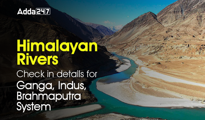
The Himalayan River is a vast river system that flows in the Northern side of India and Pakistan and the Southern Part of China and flows through Bangladesh as well. It is one of the very important topics in Social Studies and Geography subject. At least 4-5 questions are easily witnessed in the Teaching Competitive Exams every year. Therefore, teaching aspirants must read and learn about the Himalayan River Systems in depth.
Some of the most important teaching Exams for which teaching aspirants prepare are CTET, KVS, NVS, UPTET and other state TETs. In the following article, the candidates will get to know all about the Himalayan River Systems to be able to excel in their Government Teaching Exams with flying colours.
Himalayan Rivers
The Himalayan mountain complex is the source of the following three drainage systems which are joined are various tributaries to form these river systems. These river systems are long and geographically cover a vast area of India, Pakistan, Bangladesh and a significant portion of China as well.
- The Indus system
- The Ganga system
- The Brahmaputra system
The Indus River System
Indus river: The Indus rises in Tibet at an altitude of 5,180 metres near the Mansarovar Lake. With a total length of 2,880 km, the Indus is one of the world’s largest rivers.
- Jhelum river: The Jhelum river rises in Verinag at the foothills of Pir Panjal and its drainage area in India is 28,490 square kilometres.
- Chenab river: The Chenab river is the largest of all the Indus tributaries and is formed by two streams Chandra and Bhaga which rise in the snow-covered Himachal Mountains near Kulu. Its drainage area in India is 26,755 square kilometres.
- Ravi river: The Ravi river rises in Kulu hills, near Rohtang Pass, of Himachal Pradesh and drains 5,957 square kilometres in India
- Beas river: The Beas river originates at a place called Beas Kund near Rohtang Pass in the Himachal hills. In its early stages, its valley is called the Kulu valley.
- Satluj river: The Satluj river originates from the Rakas Lake situated at an altitude of 4,555 metres in Tibet. The Rakas Lake is connected with the Mansarovar Lake by a stream. The Satluj enters India through Shipki La.
The Ganga River System
The Ganga river basin, with an area within India of 8,61,404 square kilometres, is the largest in the country.
- Ganga river: The Ganga river rises in the Gangotri glacier in Uttarakhand. Its two main headstreams Bhagirathi and Alaknanda – meet at Devaprayag, from where onwards it is called the Ganga. Its total length is 2,510 km, and it drains 9,51,600 sq. km.
- Yamuna river: The Yamuna is the most important tributary of the Ganga. It rises at the Yamnotri glacier in Uttarakhand. From its source up to Allahabad, where it meets the Ganga, Yamuna’s length is 1,376 km and it drains an area of 3,59,000 square Kilometres.
- Ram Ganga river: The Ram Ganga river rises in the Kumaon Himalayas and enters the Ganga Plains near Kalagarh. It joins the Ganga near Kannauj.
- Gandak river: The Gandak river rises near the Sino-Nepal border and joins the Ganga at Sonpur. It drains an area of 9,540 square kilometres.
- Kosi river: The Kosi river has its sources in the Himalayan heights of Sikkim, Nepal and Tibet. It drains 21,500 square kilometres in India and joins the Ganga below Bhagalpur.
- Son river: The Son river is a right-bank tributary of the Ganga which, after rising from the Amarkantak Plateau, joins the Ganga near Patna. It drains an area of 71,900 square kilometres.
- Damodar river: The Damodar river which actually meets the Bhagirathi-Hooghly in West Bengal, rises in the hills of the Chhotanagpur Plateau. It drains an area of 22,000 square kilometres. Formerly referred to as the ‘Sorrow of Bengal’ on account of its floods,
- Chambal river: It rises near Mhow in the highlands of Jan a Pao Hills in MP. and enters a gorge at chaurasia. It joins Yamuna in the Etawah district of Uttar Pradesh.
- Ghaghra river: It originates near the Gurla Mandheta peak, South of Mansarovar in Tibet.
- Kali river: it rises in high glaciers of the snow-covered region of trains – the Himalayas If forms the boundary between Nepal and Kumaon. It is known as Sarda after it reaches the plains near Tanakpur.
The Brahmaputra River System
The Brahmaputra river rises in a glacier, about 100 km southeast of the Mansarovar lake in Tibet. Before entering India, it is called the Tsang-Po in Tibet. Chinese maps show it as Yarlung Zangbo Jiang. It crosses the Assam Himalayas under the name of Dihang. The total length of the Brahmaputra in India is 2,900 km, and it drains an area of 2,40,000 square kilometres in India


 UPESSC Principal Recruitment 2026 Out, A...
 PTET College Allotment List 2026 Out @pt...
 UPSC Principal and Vice Principal Previo...