Godavari River
After the Ganga, the Godavari river is the second-longest river in India. It empties into the country’s third-largest basin, which makes up 10% of its entire land area. The Godavari river, also known as the Dakshina Ganga, is the greatest river in peninsular India in terms of length, catchment area, and flow.
The river continues to house and support a rich cultural history and has long been honoured in Hindu texts. A number of barrages and dams have surrounded the river during the past few decades, maintaining a head of water (depth) that reduces evaporation. Its large river delta has a population density of 729 people per km2, which is over twice that of India as a whole. It also has a high danger of flooding, which would be made worse in lower areas if the sea level were to increase globally.
Godavari River Origin and Length
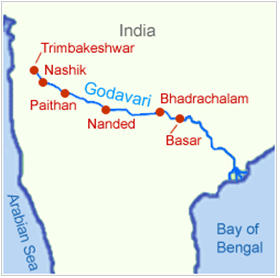
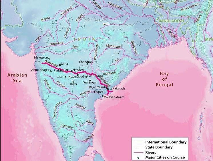
The Godavari originates in the Western Ghats of central India, 80 kilometres (50 miles) from the Arabian Sea, close to Nashik in Maharashtra. It travels 1,465 km (910 mi) along the Deccan Plateau before turning southeast and flowing into the West and East Godavari districts of Andhra Pradesh. At Dowleswaram Barrage in Rajahmundry, it splits into two distributaries that then enlarge into a sizable river delta before emptying into the Bay of Bengal.
Godavari River States
It drains the states of Maharashtra (48.6%), Telangana (18.8%), Andhra Pradesh (4.5%), Chhattisgarh (10.9%), and Odisha (5.7%) as it travels east for 1,465 kilometres (910 mi). The river has a vast network of tributaries that ultimately empty into the Bay of Bengal. It constitutes one of the largest river basins on the Indian subcontinent, with a maximum area of 312,812 km2 (120,777 sq mi). Only the Ganga and Indus rivers have a greater drainage basin.
Godavari River Map
Godavari River Tributaries
The Purna, Pranhita, Indravati, and Sabari Rivers are among the primary left bank tributaries of the river, accounting for about 59.7% of the basin’s total catchment area. The right bank tributaries Pravara, Manjira, and Manair combined make up 16.1% of the basin.
The Pranhita River, which makes up roughly 34% of the Godavari River’s drainage basin, is its greatest tributary. Although the river only flows for 113 km (70 mi), the sub-basin drains the whole Vidharba region as well as the southern Satpura Ranges due to the river’s vast tributaries, Wardha, Wainganga, and Penganga. The second-largest tributary, Indravati, is referred to as the “lifeline” of the Kalahandi, Nabarangapur, and Bastar districts of Chhattisgarh and Odisha. Both Indravati and Pranhita are regarded as independent rivers because of their sizable subbasins. The Nizam Sagar reservoir is situated in Manjira, the longest of the tributaries. In Maharashtra’s water-scarce Marathwada region, Purna is a top river.
| S.No | Name of River | Length (km) | Catchment Area (sq km) |
|---|---|---|---|
| 1 | Upper Godavari (Source to Confluence) | 675 | 33502 |
| 2 | Pravara | 208 | 6537 |
| 3 | Purna | 373 | 15579 |
| 4 | Manjira | 724 | 30844 |
| 5 | Manair | 225 | 13106 |
| 6 | Penganga | 676 | 23898 |
| 7 | Pranhita | 721 | 61093 |
| 8 | Indravati | 535 | 41655 |
| 9 | Sabari | 418 | 20427 |



 CUET BHU Cut off 2025: Course-wise and C...
 DAVV Result 2025 Out, Download Devi Ahi...
 Calicut University Timetable 2025 PDF Re...


