![India Map 2025 with States: Political Map of India, Bharat Map [New] -_0.1](https://www.adda247.com/jobs/wp-content/uploads/sites/2/2022/09/07185734/school.png)
India Map: The map of India depicts the country’s geographic features, boundaries, and key locations. India, formally known as the Republic of India, is a huge country in South Asia. India Map encompasses around 3.29 million square kilometers, making it the world’s seventh-largest country by land area. India shares borders with several countries. It shares a border with Pakistan to the northwest, and China and Nepal to the north. Bhutan is located in the northeast, and to the east, India shares borders with Bangladesh and Myanmar. In the south, the Indian Ocean surrounds the country, with the Arabian Sea on the west and the Bay of Bengal on the east.
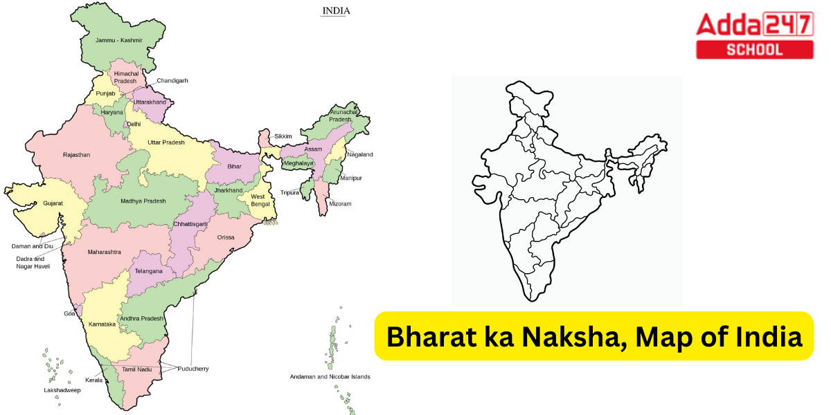
India Map 2025 with States (Explained)
The shape of the India Map can be described as a triangular peninsula, with the southern part extending into the Indian Ocean. The northern region gradually narrows towards the border with Nepal. India’s geographic landscape is diverse and encompasses various terrains. The Himalayan mountain range stretches along the northern border, providing a natural barrier.
The Gangetic Plains, one of the most fertile regions in the world, is located in the northern part of the country. Towards the northwest, you’ll find the Thar Desert, which is a large arid region. India also has a vast coastline along the Arabian Sea and the Bay of Bengal, featuring beautiful beaches and coastal plains.
The India Map depicts its states and union territories, which are administrative divisions within the country. India has 28 states and 8 union territories. Each state has its own capital city and regional governments, contributing to the cultural and linguistic diversity of the country.
Major cities such as New Delhi (the capital), Mumbai, Kolkata, Chennai, and Bangalore are prominently marked on the map. Additionally, important rivers like the Ganges, Brahmaputra, Yamuna, and Godavari, as well as significant mountain ranges, are typically shown on the India Map.
The India Map serves as a valuable tool for understanding the country’s geography, planning travel routes, studying its diverse regions, and gaining a broader perspective on its cultural and historical significance.
Map of India 2025
India Map in South Asian nations are best and big map. The India Map is most likely the most populous and seventh-largest country on the planet. India’s land borders with Pakistan to the west, China, Nepal, and Bhutan to the north, Bangladesh and Myanmar to the east, the Indian Ocean to the south, the Arabian Sea to the southwest, and the Bay of Bengal to the southeast. India shares a maritime border with Thailand, Myanmar, and Indonesia on its Andaman and Nicobar Islands, which are located in the Indian Ocean near Sri Lanka and the Maldives.
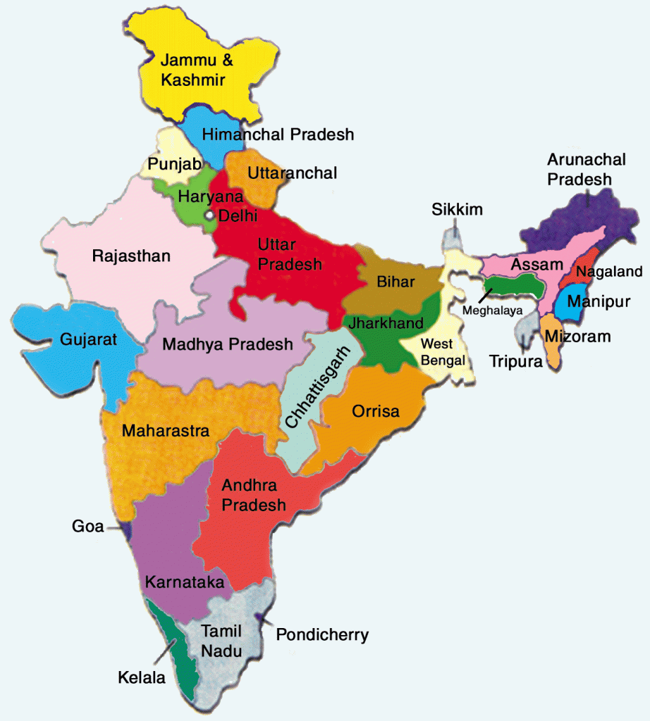
India Map with States and Capitals
India Map with States and Capitals 1. Andhra Pradesh – Amaravati 2. Arunachal Pradesh – Itanagar 3. Assam – Dispur 4. Bihar – Patna 5. Chhattisgarh – Raipur 6. Goa – Panaji 7. Gujarat – Gandhinagar 8. Haryana – Chandigarh 9. Himachal Pradesh – Shimla 10. Jammu and Kashmir – Srinagar (Summer), Jammu (Winter) 11. Jharkhand – Ranchi 12. Karnataka – Bengaluru 13. Kerala – Thiruvananthapuram 14. Madhya Pradesh – Bhopal 15. Maharashtra – Mumbai 16. Manipur – Imphal 17. Meghalaya – Shillong 18. Mizoram – Aizawl 19. Nagaland – Kohima 20. Odisha – Bhubaneswar 21. Punjab – Chandigarh 22. Rajasthan – Jaipur 23. Sikkim – Gangtok 24. Tamil Nadu – Chennai 25. Telangana – Hyderabad 26. Tripura – Agartala 27. Uttar Pradesh- Lucknow 28. Uttarakhand- Dehradun.
India has 28 states and 8 Union Territories. Following is the list of 28 states and 8 union territories of India:
Source: India Map
Political Map of India, Bharat Map
India Map with States: Political Map of India, Bharat Map, which shows all its States and Union Territories with their respective capitals:
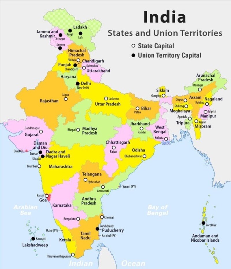
India Political Map
India Map of 28 states and 8 union territories make up the federal union of India. The Westminster system of administration is used in all states, as well as the union territories of Jammu & Kashmir, Puducherry, and the National Capital Territory of Delhi. The central government directly governs the remaining five union territories through nominated administrators. The States Reorganisation Act of 1956 reorganized states according to their primary languages. At the city, town, block, district, and village levels, there are more than a quarter of a million local government organizations.
Eastern Ghats Biodiversity, Geology, States, Map and Rivers
Western Ghats Biodiversity, States, Mountain and Highest Peak
Below is the Political Map of India which shows the division of territory inside the country in form of states and Union Territories and the Borders with the neighbouring countries:
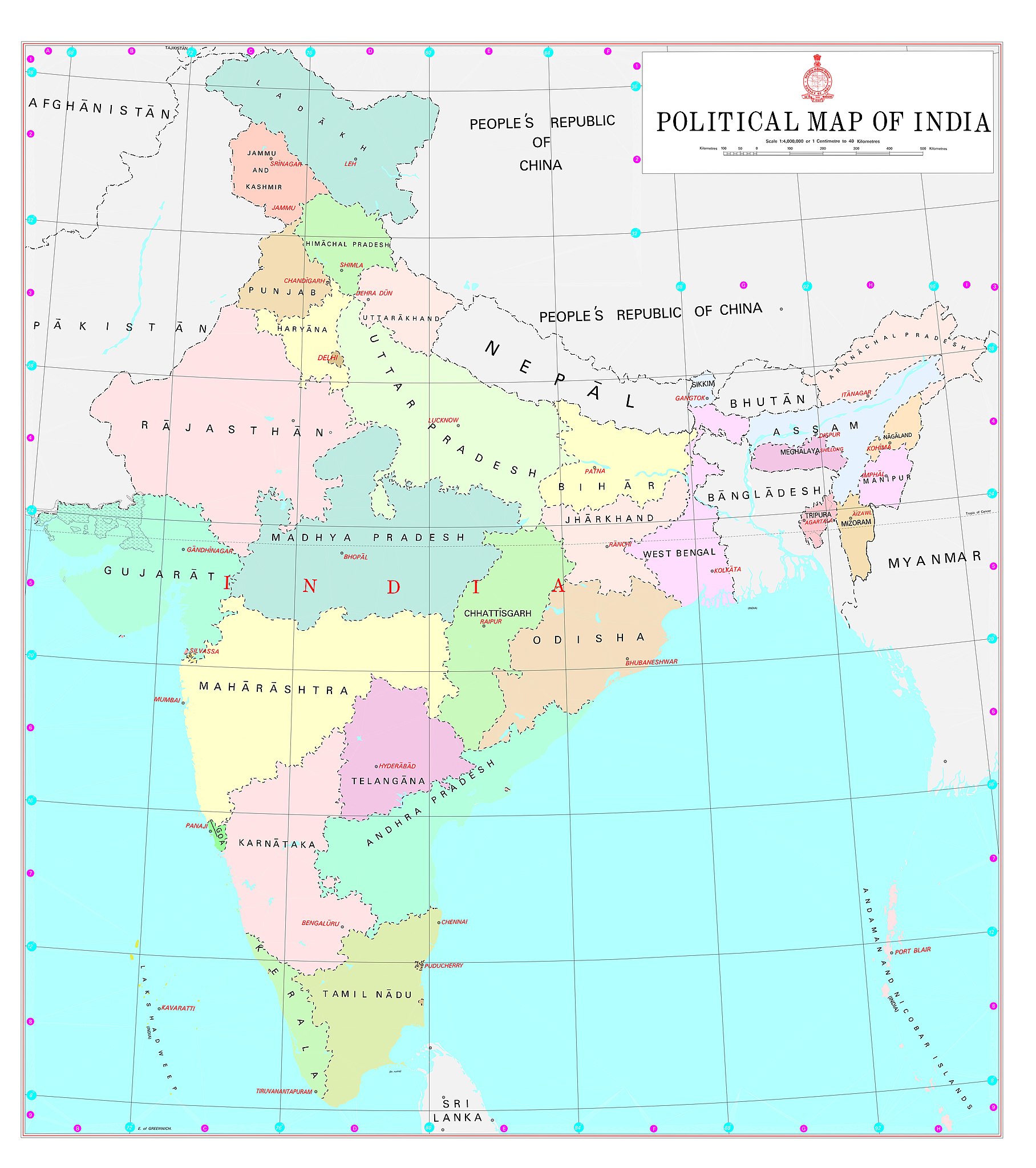
Bharat Map- India Physical Map
India Map (Physical) description is given below.
- India makes up the majority of the Indian subcontinent, which is made up of the Indo-Australian Plate and the Indian tectonic plate.
- When the Indian Plate, which was then a component of the southern supercontinent Gondwana, started to move north-eastward due to seafloor spreading to its south-west, and later, south and south-east, 75 million years ago, that is when India’s defining geological processes began.
- To its northeast, the enormous Tethyan oceanic crust started subducting beneath the Eurasian Plate at the same time.
- Both of these processes, which were fueled by convection in the Earth’s mantle, contributed to the formation of the Indian Ocean and eventually led to the underthrusting of Eurasia and the uplifting of the Himalayas by the Indian continental crust.
The Indo-Gangetic Plain is the result of a huge crescent-shaped trough that was formed by plate movement immediately south of the developing Himalayas. This valley was quickly filled with river-borne silt. The ancient Aravalli range, which stretches southwestward from the Delhi Ridge, is where the original Indian plate first appears above the sediment. The Thar Desert is located to the west, and the Aravallis prevent it from spreading to the east.
Top 10 coldest Place in India, List 2023
Below is the Physical Map of India which shows the various Physical Attributes of the country, including the Mountains, the rivers and the Soil and Climate zones:

India Map of Rivers and Coastline
The India map of Rivers and the Coastline of India are given below in this article.
India Map of Coastline
7,517 kilometers make up India’s coastline, of which 5,423 kilometers are on the peninsula and 2,094 kilometers are on the Andaman, Nicobar, and Lakshadweep island chains. The mainland’s coastline is made up of 43% sandy beaches, 11% rocky coasts, including cliffs, and 46% mudflats or marshy shores, according to Indian naval hydrographic charts.
India Map of Indian Rivers
- The Ganges and the Brahmaputra are two significant rivers with Himalayan origins that pass primarily through India and both flow into the Bay of Bengal.
- The Yamuna and the Kosi are significant tributaries of the Ganges; the latter’s unusually low gradient, brought on by prolonged sediment deposition, causes severe floods and course shifts.
- The Godavari, the Mahanadi, the Kaveri, and the Krishna, which also drain into the Bay of Bengal, as well as the Narmada and the Tapti, which drain into the Arabian Sea, are major peninsular rivers whose steeper gradients prevent their waters from flooding.
- The alluvial Sundarbans delta in eastern India and the marshy Rann of Kutch in western India are examples of coastal features.
- The latter is shared with Bangladesh. India contains two archipelagos: the Andaman and Nicobar Islands, a volcanic chain in the Andaman Sea, and the Lakshadweep, coral atolls off India’s south-western coast.
Below is the Map of India which shows the rivers of India and their courses of Origin and end into the Sea or the Ocean:

Godavari River Length, Origin, Map and Tributaries
India Map with State: Political Map of India
India is a country located in South Asia. India Map is bordered by several countries, including Pakistan to the northwest, China and Nepal to the north, Bhutan to the northeast, and Bangladesh and Myanmar to the east. To the south, India is surrounded by the Indian Ocean, with the Arabian Sea to the west and the Bay of Bengal to the east.
The shape of India Map resembles a triangle, with the southern part extending into the Indian Ocean and the northern part narrowing towards the border with Nepal. India has a diverse geographical landscape, with the Himalayan mountain range in the north, the fertile Gangetic plains, the arid Thar Desert in the northwest, and the coastal regions along its peninsular coastline.
India is the seventh-largest country by land area and the second-most populous country in the world, with a population of over 1.3 billion people. The capital city is New Delhi, and the official languages are Hindi and English, although there are several regional languages spoken across the country.
The India map typically shows its states and union territories, major cities, rivers, mountains, and other geographical features. It serves as a visual representation of India’s boundaries and helps to understand the country’s physical geography.


 Best CLAT Coaching Classes in Rajouri Ga...
 IPMAT Coaching in Rajouri Garden Delhi |...
 CUET Coaching in Rajouri Garden Delhi | ...
![India Map 2025 with States: Political Map of India, Bharat Map [New] -_8.1](https://www.adda247.com/jobs/wp-content/uploads/sites/2/2026/06/10165721/CUETSCIENCEONLINECLASSESPCB1778838622-1.webp)
![India Map 2025 with States: Political Map of India, Bharat Map [New] -_9.1](https://www.adda247.com/jobs/wp-content/uploads/sites/2/2026/06/10165720/CUETARTSONLINECLASSES1778838542-1.webp)
![India Map 2025 with States: Political Map of India, Bharat Map [New] -_10.1](https://www.adda247.com/jobs/wp-content/uploads/sites/2/2026/06/10165720/CUETSCIENCEONLINECLASSESPCM1778838598-1-1.webp)
![India Map 2025 with States: Political Map of India, Bharat Map [New] -_11.1](https://www.adda247.com/jobs/wp-content/uploads/sites/2/2026/06/10165719/CUETCOMMERCEONLINECLASSES1778838574-1-1.webp)