
Joshimath Uttarakhand
Joshimath often spelled Jyotirmath, is a municipality and a city in the Uttarakhand state of India’s Chamoli District. It is a gateway to several Himalayan mountain climbing adventures, hiking paths, and pilgrimage sites like Badrinath and is situated at a height of 6150 feet (1875 m). One of the four cardinal pthas founded by Adi Shankara is located there.
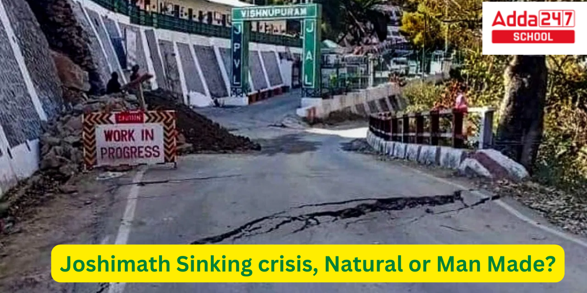
The aftermath of the 2021 Uttarakhand flood and its effects have been felt strongly in the region since February 7th. It has been determined that the town is sinking as a result of its location along a flowing ridge. People in the town had to be evacuated after the town’s surrounding structures started to crack.
joshimath Crisis for UPSC
- In recent years, Joshimath has faced a number of crises, including floods and landslides caused by heavy monsoon rains.
- In 2013, a major flash flood hit the town, causing extensive damage to infrastructure and homes.
- In 2016, another flash flood hit the area, killing over 30 people and displacing thousands.
- The Indian government has been criticized for its slow response to the crisis, and for not providing enough aid and support to affected residents.
- Many residents of Joshimath have been forced to leave their homes and seek shelter elsewhere.
- The crisis has also affected the local economy, as tourism has dropped sharply due to the damage caused by the floods.
- The Indian government has announced plans to improve the infrastructure of the town and to provide more aid to affected residents, but it remains to be seen whether these efforts will be successful in addressing the ongoing crisis.
- In 2021, another flash flood hit the area of Tapovan.
- In 2023, All of Joshimath City is Sinking.
Joshimath Sinking crisis Natural or Man Made in Uttarakhand?
Joshimath may all sink, according to satellite photos of the town issued by the National Remote Sensing Centre (NRSC) of the Indian Space Research Organization (ISRO) and a preliminary assessment on land subsidence. The Cartosat-2S satellite provided the images. The NRSC, situated near Hyderabad, has made available satellite photos of sinking regions. Images show that the entire town, together with the Narasimha shrine and the Army’s helipad, has been designated as a sensitive zone.
The government of Uttarakhand is launching rescue operations in hazardous areas and relocating residents there to safer locations on a priority basis based on the preliminary report from ISRO. The report states that Joshimath sank by 8.9 cm between April and November 2022, during which time land subsidence was gradual. However, the intensity of ground subsidence rose between December 27, 2022, and January 8, 2023, and the town sank by 5.4 cm during these 12 days.
The Joshimath-Auli road is also set to collapse as a result of the subsidence of the soil, according to satellite photographs. The findings in the ISRO’s initial report are alarming, despite the fact that scientists are still investigating the fissures that started to form in houses and roadways after the town’s ground began to sink.
Joshimath- Demography and History of Disasters
There are a total of 3,898 families living in Joshimath city as of the 2011 India census. Joshimath has a total population of 16,709, of whom 9,988 are men and 6,721 are women. As a result, Joshimath’s average sexual ratio is 673. Joshimath City has 2103 children under the age of six, or 13% of the total population. Between the ages of 0 and 6 years, there are 976 female and 1127 male children. According to the Census 2011, Joshimath’s child sex ratio is 866, which is higher than the national average (673).
Joshimath now has a 91.3% literacy rate, up from 77% in 2001, according to the Census of 2011. As a result, Joshimath has a greater literacy percentage than Chamoli, which has an illiteracy rate of 82.7%. In Joshimath, the literacy rates for men and women are 84.5% and 72.8%, respectively. There were 13,202 people living in Joshimath in 2001.
Joshimath- Glacial Outburst Flood 2021
- Residents started detecting fractures in homes after the floods; eventually, over 600 dwellings had to be evacuated after a nearby temple collapsed.
- Over 700 of the roughly 4,500 structures would eventually develop cracks, and the roadways and paved areas in the impacted area did as well.
- Authorities allowed for the evacuation of hundreds of residents, and on January 9, 2023, demolition work started in “totally safe,” “buffer,” and “risk” zones within the town.
- Residents started detecting fractures in homes after the floods; eventually, over 600 dwellings had to be evacuated after a nearby temple collapsed. Over 700 of the roughly 4,500 structures would eventually develop cracks, and the roadways and paved areas in the impacted area did as well. Authorities categorised certain portions of the town as “risk,” “buffer,” and “totally safe” areas, allowing hundreds of residents to leave; demolition work started on January 9 of 2023.
Joshimath- 1976 Mishra Committee Report
Land subsidence is currently posing a serious threat to Joshimath. Joshimath is not located on the main rock but rather on a historic sand and stone landslide deposit, according to a 1976 investigation by the Mishra Committee. This indicates that it is a part of landslide debris. The report also emphasised how the Alaknanda and Dhauliganga rivers’ undercutting by currents contributed to the landslides.
According to the research, the region is characterised by dispersed rocks covered with old landslide debris made up of boulders, gneissic rocks, and loose soil, all of which have a low bearing ability. Due to their extreme weathering and poor cohesive value, these gneissic rocks are prone to significant pore pressure when wet, especially during monsoon season.
Joshimath- Indiscriminate Construction and Negligence of Warning
Increased construction activity, hydroelectric projects, and the extension of the National Highway in the last two decades have all worsened the situation in Joshimath. The slopes are now extremely unstable and prone to landslides as a result of these efforts. Other theories for the city’s demise include the rushing streams from Vishnuprayag and sliding along natural streams.
According to several experts, the best course of action at this time would be to completely halt all hydroelectric and development projects in the area. The population must first be moved to a safer area, and only then could the town’s planning be revised to account for the new variables and shifting geographical conditions.
Joshimath- Historical Importance
Katyuri kings dominated the region to varied degrees between the 7th and 11th century C.E. from their capital in Kumaon’s “Katyur” valley (today’s Baijnath). Vashudev Katyuri established the Katyuri dynasty. Vasu Dev is credited for building the antecedent Joshimath Basdeo temple. Vasu Dev was originally a Buddhist, but eventually adopted Brahminical practises. The Brahminical practises of the Katyuri monarchs in general are frequently credited to an active Adi Shankara campaign (788-820 CE).
- Joshimath was the Katyur dynasty’s initial capital, and they afterwards relocated to Kartikeyapur, Badari dutt pande claimed in his book “kumaon ka itihas” (modern day Baijnath).
- In the eleventh century AD, the Panwar dynasty replaced the Katyuri kings.
Joshimath- Religious Importance
- One of the four cardinal institutions founded by Adi Shankara, the others being those at Shringeri, Puri, Dwarka, and Kanchi, Jyotirmath is the uttarmnya matha, or northern monastery.
- The word “Shankaracharya” appears on their heads. This matha is in charge of the Atharvaveda, in accordance with the tradition started by Adi Shankara.
- Jyotirmath is adjacent to Badrinath, a popular destination for pilgrims.
- Travelers heading to the Valley of Flowers National Park or Guru Gobind Ghat may use this location as a base camp.
- Badrinarayan is worshipped at the Narasimha temple among a pantheon of gods. Adi Sankara is credited with creating the ruling god Lord Narasimha.
Joshimath- Army Cantonment
One of the significant Indian Army military installations in Uttarakhand is Joshimath Cantonment. It serves as “The Garhwal Scouts'” permanent post, the scout battalion of the Garhwal Rifles. The army station is the nearest to the Indo-Tibetan Border. It served as a base camp for the 2013 Kedarnath Floods rescue operation.
Joshimath Uttarakhand History
Joshimath is a town located in the Indian state of Uttarakhand. It is known as one of the “four mathas” or monasteries established by the 8th century Indian philosopher and saint, Adi Shankara. The town is also a popular pilgrimage spot for Hindus, as it is home to the temple of Lord Badrinath, one of the four sacred temples in the Char Dham pilgrimage circuit. Joshimath has a long history of religious and cultural significance, and is considered an important center of learning and education in the region.
Joshimath Uttarakhand History All Facts for UPSC
- Joshimath is a historical town located in the Indian state of Uttarakhand. It is situated in the Chamoli district and is one of the four mathas (monasteries) established by Adi Shankaracharya, a Hindu philosopher and theologian, in the 8th century AD.
- The town is located at an altitude of 1,890 meters above sea level and is surrounded by the Nanda Devi and Trishul mountain ranges.
- Joshimath is considered to be a sacred place for Hindus and is visited by thousands of devotees every year. It is believed that Adi Shankaracharya attained enlightenment here.
- The town is also known for its ancient temples, including the Narsingh Temple, which is dedicated to Lord Vishnu and is believed to have been built in the 9th century AD.
- Joshimath is also an important pilgrimage site for the followers of the Badrinath Temple, one of the four sacred shrines in Hinduism. The temple is located in the nearby town of Badrinath and is visited by thousands of pilgrims every year.
- The town is also a popular destination for trekkers and hikers, with many trekking routes passing through the surrounding mountains.
- Joshimath is well-connected to major towns and cities in Uttarakhand and other parts of India. The nearest airport is Jolly Grant Airport in Dehradun, which is around 286 kilometers away.
- The town is also known for its beautiful landscapes and scenic views, making it a popular destination for photography and nature lovers.
- The history of Joshimath is closely linked to the history of the Indian subcontinent. The town was a major center of learning and culture in ancient India and has been a site of religious and spiritual significance for centuries.
- Today, Joshimath is a bustling town with a rich cultural heritage, and it continues to be an important pilgrimage site for Hindus.

 CLAT 2027 Preparation: Complete Study Pl...
 Best CLAT Online Course 2027: Why Adda24...
 Best Strategy to Attempt the CUET Exam f...