
India Rivers Map
India rivers map shows the majority of significant Indian cities are found along the banks of the country’s rivers. The rivers of India are revered as sacred by all Hindus in India and play a significant role in Hindu mythology. In this India rivers map, you can see the Ganges, Yamuna (a tributary of the Ganges), Brahmaputra, Mahanadi, Narmada, Godavari, Tapi, Krishna, and Kaveri are the nine major rivers in India. The Indus River also crosses Indian territory in several places. Look at the map of the Indian rivers given below for better understanding.
River Map of India
India is a country with numerous rivers flowing through its vast landscape. Some of the major rivers in India include:
Ganges River (Ganga): The Ganges is one of the most sacred rivers in India and flows through northern India, originating in the Himalayas and eventually emptying into the Bay of Bengal. Major cities along the Ganges include Varanasi, Allahabad, and Kolkata.
Yamuna River: The Yamuna is another important river in northern India, which is a tributary of the Ganges. It flows through states like Uttarakhand, Himachal Pradesh, Haryana, and Uttar Pradesh, passing through Delhi before merging with the Ganges at Allahabad.
Brahmaputra River: This river flows through northeastern India and is one of the major rivers in the region. It originates in Tibet, flows through Arunachal Pradesh and Assam before entering Bangladesh.
Indus River: The Indus River flows through the northwestern part of India and is primarily located in Pakistan. It originates in Tibet, enters India in the Ladakh region of Jammu and Kashmir, and then flows into Pakistan.
Krishna River: The Krishna River flows through the southern part of India, originating in the Western Ghats and flowing through states like Maharashtra, Karnataka, Telangana, and Andhra Pradesh before emptying into the Bay of Bengal.
Godavari River: The Godavari is the second-longest river in India and flows through central and southern India. It originates in Maharashtra and flows through states like Telangana, Andhra Pradesh, and Chhattisgarh before draining into the Bay of Bengal.
Narmada River: The Narmada River flows through central India, originating in Madhya Pradesh and flowing westward through Gujarat before emptying into the Arabian Sea.
Tapti River: The Tapti River also flows through central India, originating in Madhya Pradesh and flowing westward through Maharashtra and Gujarat before draining into the Arabian Sea.
Mahanadi River: The Mahanadi River flows through the eastern part of India, primarily in the state of Odisha, before emptying into the Bay of Bengal.
Cauvery River: The Cauvery River flows through southern India, originating in Karnataka and flowing through Tamil Nadu before emptying into the Bay of Bengal.
These are some of the major rivers in India, and there are many smaller rivers and tributaries that crisscross the country’s diverse landscape. Please note that the exact course and length of these rivers may vary slightly, and it’s always a good idea to refer to an up-to-date map for precise information.
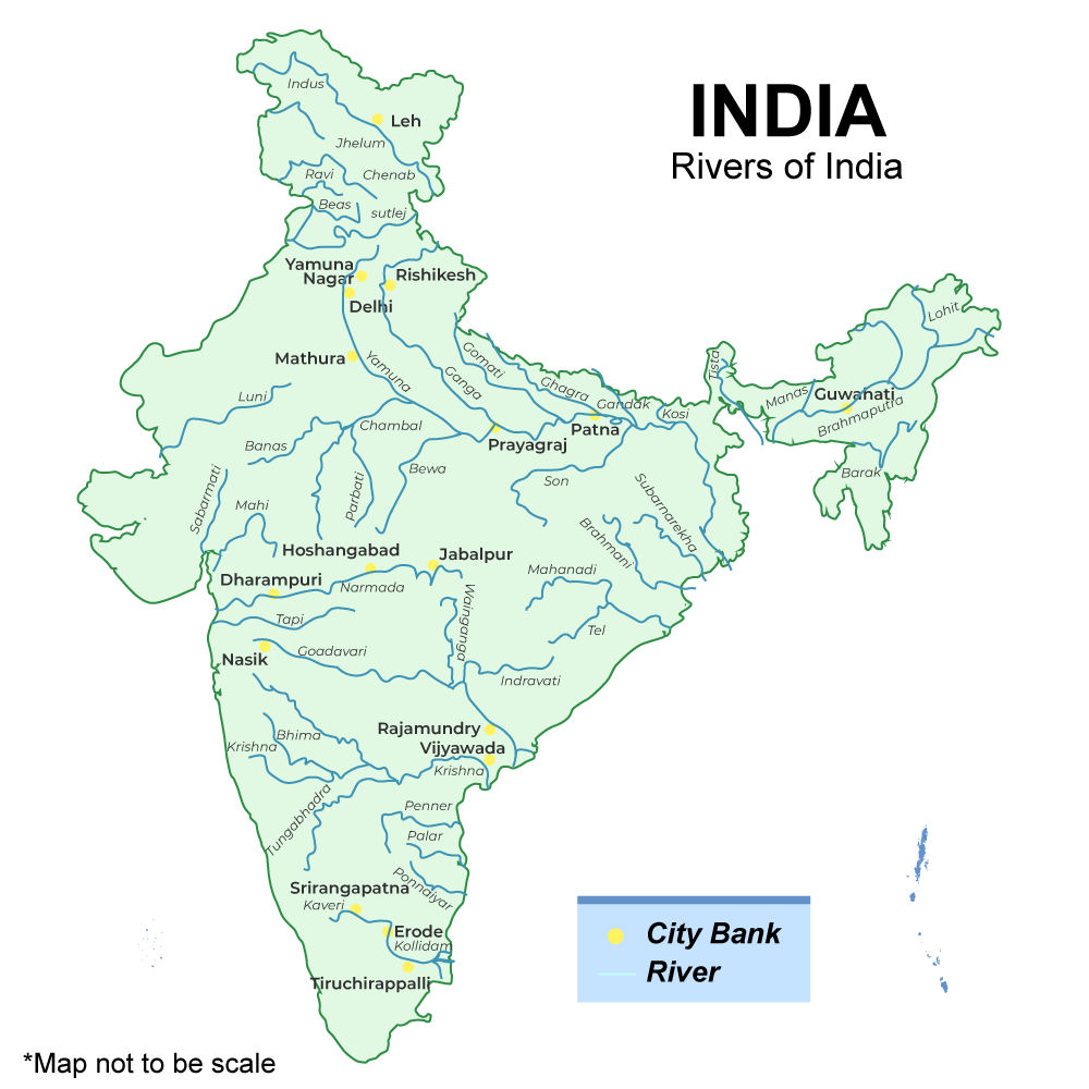
River Map of India- Indian River System Map
Indian rivers map and river map of india is given below.
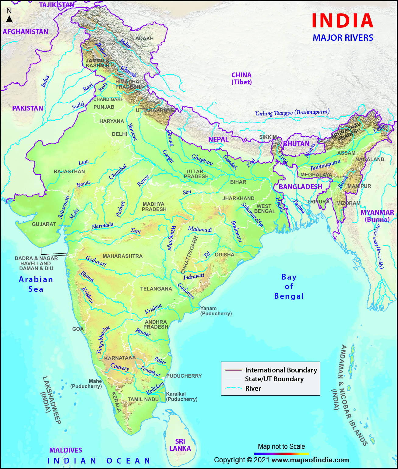
Source: Maps of India
Indian Rivers
Rivers of India are considered the basic needs of Indian people as they depend heavily on the rivers of India. The India’s river systems support a huge number of people’s livelihoods by offering irrigation, potable water, affordable transportation, and energy. This explains very simply why almost all of India’s main cities are situated along riverbanks. The rivers of India are revered by all Hindus in the nation and play a significant role in Hindu mythology.
Rivers of India are basically divided into two categories- Himalayan rivers and Peninsular Rivers.
- The Himalayan Rivers, as their name suggests, run through the Northern Plains after originating in the Himalayas.
- Peninsular River or Peninsular Drainage originaes from the western Ghats. These rivers either flow eastward into the Bay of Bengal or westward into the Arabian Sea because the Western Ghats create a “water split.” Peninsular Rivers are rivers that are “rain-fed.”
India River Map with Names
The given table consisted india river map with names which comes under Himalayas river and Peninsular Rivers
| Himalaya Rivers | Peninsular Rivers |
| The Indus River System | Mahanadi |
| The Ganga River System | Godavari |
| The Yamuna River System | Krishna |
| The Brahmaputra River System | Cauvery |
Indian River System Map with Names
A table is given below which includes some details about the indian river system map. Read the table and details about the Indian river system.
| Indian River System | ||
| River System | Total length | Length in India |
| Brahmaputra River System | 2900 km | 916 km |
| Cauvery River System | 805 km | 805 km |
| Ganga River System | 2510 km | 2510 km |
| Godavari River System | 1465 km | 1465 km |
| Indus River System | 3180 km | 1114 km |
| Krishna River System | 1400 km | 1400 km |
| Mahanadi River System | 851 km | 851 km |
| Narmada River System | 1312 km | 1312 km |
| Tapi River System | 724 km | 724 km |
| Yamuna river System | 1376 km | 1376 km |
Indian Himalayan River System
Here we discussed various Indian River Systems. Read the article till the end
The Indus River System
The Indus rises from the northern Kailash mountain close to Lake Mansarovar in Tibet.
- Its length from the source to the point near Karachi where it empties into the Arabian Sea is around 2897 km, of which approximately 700 km are in India. It has a significant number of tributaries in both India and Pakistan.
- It creates a beautiful gorge when it enters Indian Territory in Jammu & Kashmir.
- It unites with other tributaries in the Kashmir region, including the Zaskar, the Shyok, the Nubra, and the Hunza.
- In Leh, it flows between the Zaskar Range and the Ladakh Range.
- Near Attock, which is located north of Nanga Parbat, it crosses the Himalayas through a gorge that is 5181 metres deep.
The major tributaries come under the Indus River in India are Jhelum, Ravi, Chenab, Beas, and Sutlej.
The Brahmaputra River System
The Indus and Sutlej rivers as well as the Brahmaputra all have their beginnings in Mansarovar Lake.
- It is 848 kilometres long, somewhat longer than the Indus River.
- The majority of its route is outside of India.
- It moves eastward in a straight line parallel to the Himalayas. It makes a U-turn to avoid Namcha Barwa and enters India’s state of Arunachal Pradesh after that.
- It is referred to as the Dihang River here. It flows across the Indian states of Assam and Arunachal Pradesh and is joined by a number of tributaries.
- In Assam, the Brahmaputra flows via a braided channel for the majority of its length.
In Tibet, the river is referred to as the Tsangpo. In the Tibet region, there is less silt and less water input. However, the river in India travels through an area of intense precipitation; as a result, the river carries a sizable amount of sediment in addition to massive amounts of water during rainfall. In terms of volume, it is regarded as one of India’s biggest rivers. It is infamous for causing disasters in Bangladesh and Assam.
The Ganga River System
Hindus consider Ganga to be the most sacred river, and they revere her as the goddess Ganga. It is also one of the most polluted rivers, which is ironic. A variety of aquatic species are also under peril, not only people.
- From the Gangotri Glacier, the Ganga emerges as the Bhagirathi.
- The Mandakini, Pindar, Dhauliganga, and Bishenganga rivers combine to form the Alaknanda before it reaches Devprayag in the Garhwal Division, while the Bheling river drains into the Bhagirathi.
- East Trishul is where the Pindar River rises, and Karan Prayag is where Nanda Devi joins the Alaknanda. At Rudraprayag, the Mandakini congregates.
- At Devprayag, water from the Alaknanda and the Bhagirathi rivers flows in the name of the Ganga.
The concept of Panch Prayag
- Vishnuprayag: Where the Alaknanda River meets the Dhauli Ganga River is Vishnuprayag.
- Nandprayag: Alaknanda meets the Nandakini at Nandprayag.
- Karnaprayag: Alaknanda meets the Pinder at Karnaprayag.
- Rudraprayag: the confluence of the Alaknanda and Mandakini rivers.
- Devprayag: the confluence of the Alaknanda and the Bhagirathi.
The Yamuna, Damodar, Sapta Kosi, Ram Ganga, Gomati, Ghaghara, and Son are the main tributaries of the Ganga. The river flows into the Bay of Bengal 2525 kilometres after leaving its source.
The Yamuna River System
The term “yama,” which means “twin” in Sanskrit, is the source of the name Yamuna, which may have been given to the river since it flows parallel to the Ganges.
It is the second-largest and longest Ganges tributary river.
- The Yamuna River is the Ganga River’s biggest tributary.
- It comes from the Bandarpoonch hill in Uttarakhand, where the Yamunotri glacier is located.
- The Sin, Hindon, Betwa Ken, and Chambal are some of the principal tributaries that enter the river.
- The Tons is the Yamuna’s biggest tributary.
- The states of Delhi, Himachal Pradesh, Uttar Pradesh, Haryana, Rajasthan, and Madhya Pradesh are included in the river’s catchment area.
Indian Peninsular Rivers System
Check here various Indian Peninsular Rivers System in brief.
The Narmada or Tapi River System
- In the heart of India, there is a river called the Narmada.
- It ascends to the top of Madhya Pradesh’s Amarkantak Hill.
- It delineates the old border between North and South India.
- It is one of Peninsular India’s principal rivers. Only three rivers flow from east to west: the Narmada, Tapti, and Mahi.
- The river runs through the states of Gujarat, Maharashtra, and Madhya Pradesh.
- It empties into the Arabian Sea in Gujarat’s Bharuch district.
- The river also flows through a few Gujarat and Madhya Pradeshi districts.
- The Waghur River, Aner River, Girna River, Purna River, Panzara River, and Bori River are the main tributaries of the Tapi River.
The Godavari River System
- Godavari is the second-longest river in India with brownish water.
- The river is frequently referred to as the Vriddh (Old) Ganga or the Dakshin (South) Ganga.
- It is a seasonal river that widens during the monsoon season and dries up during the summer.
- This river’s source is Trimbakeshwar, which is close to Nasik in Maharashtra.
- It travels through the states of Madhya Pradesh, Telangana, Andhra Pradesh, and Orissa as it meanders southeast across south-central India before emptying into the Bay of Bengal.
- At Rajahmundry, the river creates a lush delta.
- There are numerous holy places along these riverbanks, including Nasik (MH), Bhadrachalam (TS), and Trimbak. Pranahita (Combination of Penuganga and Warda), Indravati River, Bindusara, Sabari, and Manjira are a few of its tributaries.
- On the Godavari River, Kovvur and Rajahmundry are connected by the largest rail-road bridge in Asia.
The Krishna River System
- One of India’s longest rivers, the Krishna, rises near Mahabaleshwar in Maharashtra.
- It drains the sea in the Bay of Bengal through Sangli.
- Telangana, Andhra Pradesh, Karnataka, and Maharashtra are among the states through which the river runs.
- The primary tributary, the Tungabhadra River, is created by the Western Ghats-originating Tunga and Bhadra rivers.
- Other tributaries are the Dudhganga Rivers, Koyna, Bhima, Mallaprabha, Dindi, Ghataprabha, Warna, Yerla, and Musi.
The Kaveri River System
- It comes from Talakaveri, which is a region in the Western Ghats.
- It is a well-known tourist destination and place of worship in Karnataka’s Kodagu region.
- The river’s headwaters are in the Karnataka state’s Western Ghats range, and they originate there through Tamil Nadu.
- The Bay of Bengal receives the river’s drainage. The river aids in agricultural irrigation and is seen as a source of support for South India’s modern cities and ancient kingdoms.
- There are numerous tributaries to the river, including those with the names Arkavathy, Shimsha, Hemavati, Kapila, Shimsha, Honnuhole, Amaravati, Lakshmana Kabini, Lokapavani, Bhavani, Noyyal, and Tirtha.
The Mahanadi River System
- The Mahanadi is a river in eastern India that has its source in the Satpura Range of central India.
- Towards the Bay of Bengal, it flows east. The river drains the states of Orissa, Jharkhand, Chhattisgarh, and Maharashtra.
- The Hirakud Dam, the biggest dam, is situated on a river.
Indian Rivers and Their origin
The table given below gives all the details about the rivers of India and their origin. The Indian River System is made up of eight significant rivers with some small rivers and a number of tributaries. The bulk of rivers empty their contents into the Bay of Bengal, however a few rivers whose courses pass western India and flow eastward also release their water into the Arabian Sea. Go through the table and read the rivers of India and their origin with all the details.
| RIVER SYSTEM OF INDIA | |||||
| Name of the River | Length (km) | Area | Originates From | Ends in | Places Benefited |
| Brahmaputra | 916 – in India | 194413 Sq.Km. – in India | Angsi glacier in Tibet | Bay of Bengal | Assam, Arunachal Pradesh |
| Ganga (Bhagirathi) | 2525 | 1.08 million Sq.Km. | Gangotri in Uttrakhand | Bay of Bengal | Uttar Pradesh, Uttrakhand, Bihar, West Bengal |
| Godavari | 1465 | 3,12,812 Sq.Km. | Triambakeshwar in Maharashtra | Bay of Bengal | South-eastern part of Andhra Pradesh |
| Indus | 3180/ 1114 in India | 3,21,289 Sq.Km. | in Tibet in northern slopes of Mount Kailash | Arabian sea | India and Pakistan |
| Kaveri (Dakshina Ganga or Ganges of the south) | 765 | 81155 Sq.Km. | Brahmagiri hills in Kogadu, Karnataka | Bay of Bengal | Karnataka and Tamil Nadu |
| Krishna | 1400 | 258948 Sq.Km. | Mahabaleshwar in Maharashtra | Bay of Bengal | Maharashtra & Andhra Pradesh |
| Mahanadi | 858 | 1,41,600 Sq.Km. | Sihava mountains of Chhattisgarh | Bay of Bengal | Jharkhand, Chhattisgarh, Orissa |
| Narmada | 1312 | 98,796 Sq.Km. | Amarkantak in Madhya Pradesh | Arabian Sea | Madhya Pradesh and Maharashtra |
| Periyar | 244 | 5,398 Sq.Km. | Sivagiri peaks of Sundaramala, Tamil Nadu. | Bay of Bengal | Tamil Nadu and Kerala |
| Tapti | 724 | 65,300 Sq.Km. | Betul district of Madhya Pradesh in the Satpura range | Arabian Sea | Madhya Pradesh and Maharashtra |
| Thamirabarani | 185 | 4,400 Sq.Km. | Agastyarkoodam peak of Pothigai hills of the Western Ghats, | Gulf of Mannar | Tamil Nadu |
| Vaigai | 258 | 7,741Sq.Km. | Varusanadu Hills | Bay of Bengal | Madurai in Tamil Nadu |
| Yamuna (Jamuna) | 1376 | 366223 Sq.Km. | Yamunotri in Garhwall | Bay of Bengal | Delhi, Haryana and UP |


 All Country Name List in Alphabetical Or...
 Eastern Ghats in India: Check Map, State...
 Sustainable Development Project Class 10...