
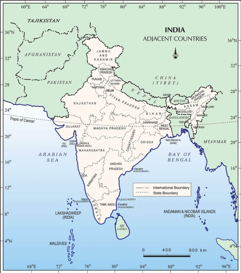
Neighbouring Countries of India
Neighbouring Countries of India are discussed here. In addition to China, Bhutan, Nepal, Pakistan, Bangladesh, and Myanmar, India has land borders with China, Bhutan, Nepal, Pakistan, Bangladesh, and Myanmar. Bangladesh and Pakistan have land and sea borders, whereas Sri Lanka only shares a maritime border through Ram Setu. Thailand, Myanmar, and Indonesia have a maritime boundary with India’s Andaman & Nicobar Islands.
Neighbouring Countries of India with Land border
Neighbouring Countries of India with Land boarder list is given here. Seven sovereign nations share India’s territorial boundaries. As part of its claim to the Kashmir area, the state’s Ministry of Home Affairs recognises a 106-kilometer (66-mile) land boundary with Afghanistan (see Durand Line).
| Land Border Country | Length of Border | Indian Force for gurading the Border | Type of Border and Border Name | |
| Bangladesh | 4,096 kilometres | Border Security Force | ||
| Bhutan | 578 kilometres | Sashastra Seema Bal | ||
| China | 3,488 kilometres | Indo-Tibetan Border Police and Special Frontier Force | McMohan Line and Line of Actual Control (LAC) | |
| Myanmar | 1,643 kilometres | Assam Rifles and Indian Army | India-Myanmar Barrier | |
| Nepal | 1,752 kilometres | Sashastra Seema Bal | Open Road Border | |
| Pakistan | 3,310 kilometres | Border Security Force | Radcliff Line and Line of Control (LOC) | |
| Sri Lanka | 0.1 kilometres | Border Security Force | Does not Exist Anymore | |
Bangladesh-India Border
The Bangladesh–India border, also known as the International Border (IB), is an international border that runs between Bangladesh and India and divides the country into eight divisions. Bangladesh and India share a 4,096-kilometer international border, which is the world’s fifth-longest land border, including 262 kilometres in Assam, 856 kilometres in Tripura, 318 kilometres in Mizoram, 443 kilometres in Meghalaya, and 2,217 kilometres in West Bengal. Along the border are the Bangladeshi divisions of Mymensingh, Khulna, Rajshahi, Rangpur, Sylhet, and Chittagong. The border between the two states is marked by a number of pillars. On both sides, little delimited sections of the boundary are fenced.
Bhutan-India Border
The open international boundary dividing Bhutan and India is known as the Bhutan–India border. The 699-kilometer border connects the Indian states of Assam (267 kilometres), Arunachal Pradesh (217 kilometres), West Bengal (183 kilometres), and Sikkim (32 km).
China-India Border
The McMahon Line is a border between Tibet and Assam in British India that was agreed at the end of the Shimla Conference (October 1913–July 1914) and named after Sir Henry McMahon, the senior British negotiator. It goes from the eastern border of Bhutan along the crest of the Himalayas until it reaches the huge bend in the Brahmaputra River where that river emerges from its Tibetan course into the Assam Valley.
Myanmar-India Border
The international border between India and Myanmar is known as the India–Myanmar border (formerly Burma). From the tripoint with China in the north to the tripoint with Bangladesh in the south, the boundary is 1,643 kilometres long.
Nepal-India Border
The open international border between India and Nepal is known as the India–Nepal border. The Himalayan areas, as well as the Indo-Gangetic Plain, are separated by a 1,770 km border. After the Sugauli Treaty of 1816 between Nepal and the British Raj, the current border was established. The existing border was designated as the border between Nepal and the Republic of India after India gained independence.
Pakistan-India Border
The International Border (IB), often known as the India–Pakistan border, is the international line that divides India and Pakistan. The Line of Control, which divides India from Pakistan-administered Kashmir, is at its northern end, and Sir Creek, a tidal estuary in the Rann of Kutch between the Indian state of Gujarat and the Pakistani province of Sindh, is at its southern end.
Sri Lanka-India Border
The maritime boundary between India and Sri Lanka was created through a pair of bilateral agreements signed in 1974 and 1976, and it stretches for 288 kilometres from the Maldives’ tripoint in the west to India and Sri Lanka’s 200 nautical mile limit in the east.
7 Neighbouring Countries of India with Maritime borders
Neighbouring Countries of India with maritime Borders list is given below. India’s marine borders are defined by the United Nations Convention on the Law of the Sea, which encompasses territorial waters, contiguous zones, and exclusive economic zones. India has a more than 7,000-kilometer maritime border with seven countries, with a 12-nautical-mile (22 km) territorial maritime zone and a 200-nautical-mile (370 km) exclusive economic zone.
The Following Countries share a maritime border with India:
- Bangladesh
- Indonesia
- Myanmar
- Pakistan
- Thailand
- Sri Lanka
- Maldives
All these countries have a maritime border more than of 400 km in length.
Neighbouring Countries of India and their capitals
Neighbouring Countries of India with their capital list is given below.
| Country | Capital | Border Length | Bordering States |
|---|---|---|---|
| Afghanistan | Kabul | 106 Km | Ladakh (PoK) |
| Bangladesh | Dhaka | 4096.7 Km | West Bengal, Meghalaya, Mizoram, Tripura and Assam |
| Bhutan | Thimphu | 699 Km | West Bengal, Sikkim, Arunachal Pradesh & Assam |
| China | Beijing | 3488 Km | Ladakh, Himachal Pradesh, Uttarakhand, Sikkim and Arunachal Pradesh |
| Myanmar | Naypyidaw, Yangon | 1643 Km | Arunachal Pradesh, Nagaland, Mizoram and Manipur |
| Nepal | Kathmandu | 1751 Km | Bihar, Uttarakhand, UP, Sikkim and West Bengal |
| Pakistan | Islamabad | 3323 Km | Jammu and Kashmir, Ladakh, Punjab, Rajasthan and Gujarat |
| Sri Lanka | Colombo (Commercial), Sri Jayawardenepura Kotte (Legislative) | Sea Border | It is separated to India by Gulf of Mannar |
| Maldives | Male | Sea Border | It lies in the south-west part of India Ocean below the Lakshadweep Island |
9 Neighbouring countries of India 2022
1- Afghanistan
Border Length- 106 km
Official Languages – Dari, Pashto
Currency – Afghan Afghani
2- Bangladesh
Border Line – 4096.7 Km
Official Language – Bengali
Currency – Bangladeshi Taka
3- Bhutan
Border Line – 699 km
Official Language – Dzongkha
Currency – Ngultrum
4- China
Border Line – 3488 km
Official Language – Mandarin
Currency – Chinese Yuan
5- Myanmar
Border Line – 1643 km
Official Language – Burmese
Currency – Burmese Kyat
6- Nepal
Border Line – 1751 km
Official Language – Nepali
Currency – Nepalese Rupee
7- Pakistan
Border Line – 3323 km
Official Language – Urdu
Currency – Pakistani Rupee
8- Sri Lanka
Border Line – Sea Border
Official Language – Sinhala, Tamil
Currency – Sri Lankan Rupee
9- Maldives
Border Line – Sea Border
Official Language – Dhivehi
Currency – Maldivian Rufiyaa
 CLAT 2027 Preparation: Complete Study Pl...
 Best CLAT Online Course 2027: Why Adda24...
 Best Strategy to Attempt the CUET Exam f...