
Class 12 Geography Map work Questions are an essential component of the CBSE Senior Secondary Geography Board Exam paper. Every year, two map-based questions are asked in the Class 12 Geography Question paper, carrying 5 marks each. The two questions are mainly on India and world geography. In the Class 12 Geography map work questions, you need to identify and mark the locations of geographical features, agricultural goods, industries, and transportation networks on India and global outline maps. In this article, we have supplied some key class 12 geography map work solutions that have either been previously asked by CBSE or appear in their sample papers.
Class 12 Geography Map Work Questions 2026
Class 12 Geography Map work Questions play a crucial role in Class 12 Board Exams since they assess students’ abilities to locate, identify, and analyse geographical features, areas, and resources. With careful revision and practice, you can easily receive full marks in this area and improve your total Geography score. These questions are normally simple and straightforward if properly prepared; however, many students disregard them throughout preparation. Mark key agricultural states, industrial areas, seaports, and international airports with suitable icons on blank maps.
Important map questions for Class 12 Geography
If you face trouble in solving the CBSE Class 12 Geography Map Work questions, then don’t worry. We suggest that you watch the attached video, where our faculty explained all the Important map questions for class 12 geography in one go.
Class 12 Geography Map Work Solutions 2025-26
1. Locate and label any five of the following geographical features on the Political Outline map of India with appropriate symbols:
A. An important iron ore mine in Odisha.
B. Southernmost seaport of India
C. An oil refinery in Gujarat
D. The state with highest population density.
E. The state leading in the production of tea
F. An international airport in Karnataka.
G. An important coal mine in West Bengal
Answer:
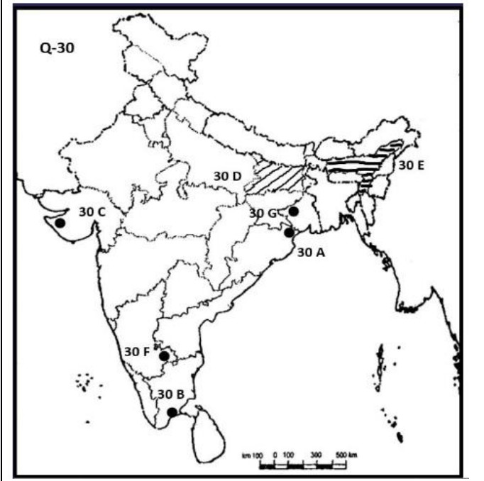
A. Mayurbhanj
B. Tuticorin
C. Jamnagar
D. Bihar
E. Assam
F. Bengaluru
G. Raniganj
2. On the given political map of the World, seven geographical features have been marked as A, B, C, D, E, F and G. Identify any five with the help of the following information and write their correct names.
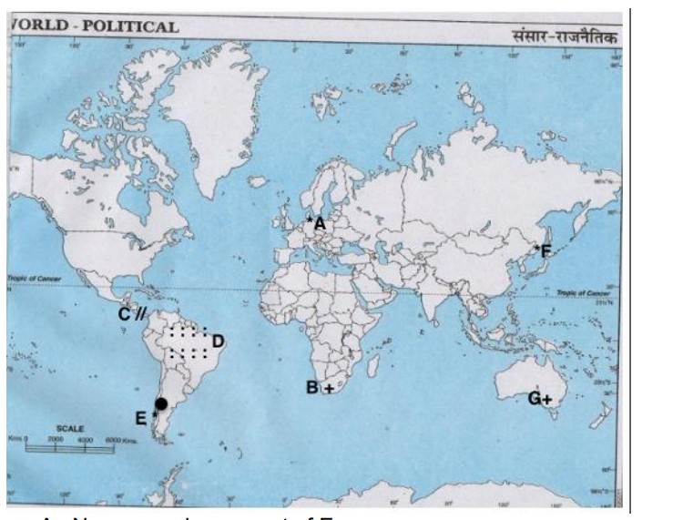
A. Name a major seaport of Europe.
B. Name an important seaport located in South Africa.
C. Name the canal that connects Atlantic Ocean and Pacific Ocean
D. Name an area of subsistence gathering in South America.
E. Name one major airport of South America.
F. Name the easternmost terminal station of Trans-Siberian Railway.
G. Name the area of extensive commercial grain agriculture in Australia.
Answer:
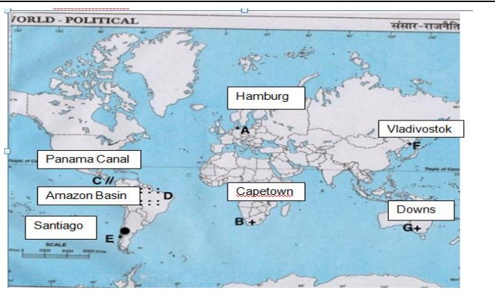
A Hamburg
B Capetown
C Panama Canal
D Amazon Basin
E Santiago
F Vladivostok
G Downs


 Karnataka 2nd PUC Result 2026 Date, Down...
 RSKMP Result 8th Class 2026 Declared @rs...
 Karnataka SSLC 10th Answer Key 2026 Rele...