


Correct option is B
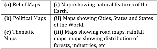
The correct answer is (a) – (i), (b) – (ii), (c) – (iii).
Relief Maps
- Maps showing natural features of the Earth include representations of mountains, valleys, plains, and other topographical elements.
- Often use colour gradients, shading, and contour lines to depict elevation and terrain.
Political Maps
- Maps showing Cities, States and States of the World typically outline the boundaries of countries, states, and municipalities.
- Highlight political and administrative boundaries and important cities.
- Often used for educational purposes and by travellers to understand geopolitical divisions.
Thematic Maps
- Maps showing road maps, rainfall maps, maps showing distribution of forests, industries, etc. focus on specific themes or topics, such as climate, population distribution, or economic activities.
- Utilize various colour, symbols, and data visualization techniques to convey specific information about a particular aspect of geography or society.
 English
 150 Questions
 150 Marks
 150 Mins
