
Table of Contents
TNPSC Field Surveyor & Draftsman Notification 2022: TNPSC Field Surveyor & Draftsman Notification 2022 Tamil Nadu Public Service Commission has released the official notification for the recruitment for Field Surveyor and other post there are 1089 vacancies .The application process will be Starts on 29.07.2022 and the last date for the online submission of the application is 27.08.2022.Read the below article to get full information about TNPSC Field Surveyor & Draftsman Notification 2022.
| Name of the Organization | Tamil Nadu Public Service Commission (TNPSC) |
| Post Name | Field Surveyor, Draftsman, Surveyor cum Asst Draftsman |
| Job Type | Govt job |
| Vacancies | 1089 |
| Salary | Rs. 19,500-71,900 |
| Location | Tamil Nadu |
| Starting Date of Online Submission | 29.07.2022 |
| Closing Date of Submission | 27.08.2022 |
| Official Website | www.tnpsc.gov.in |
Fill the Form and Get All The Latest Job Alerts
TNPSC Field Surveyor & Draftsman Notification 2022
தமிழ்நாடு அரசுப் பணியாளர் தேர்வாணையம், தமிழ்நாடு நில அளவையாளர் மற்றும் வரைவாளர் பணிகளுக்கான நேரடி ஆட்சேர்ப்புக்காக தமிழ்நாடு நில அளவையாளர் மற்றும் நிலப் பதிவேடுகள் துணைப் பணியில் சேர்க்கப்பட்டுள்ளது, மேலும் தமிழ்நாடு நகர் மற்றும் நாட்டுப்புறத் திட்டமிடல் துணைப் பணியில் உள்ள சர்வேயர் மற்றும் உதவி வரைவாளர் ஆகிய பணியிடங்களுக்கு நேரடி ஆட்சேர்ப்புக்கு அறிவிக்கப்பட்டுள்ளது. இந்த வேலைவாய்ப்பு மூலம் மொத்தம் 1089 வரைவாளர் மற்றும் கள ஆய்வாளர் பணியிடங்களை TNPSC நிரப்ப உள்ளது. TNPSC வரைவாளர் வேலைகளில் ஆர்வமுள்ள விண்ணப்பதாரர்கள் இந்த வேலைக்குத் தவறாமல் விண்ணப்பிக்கலாம். இந்த TNPSC டிராஃப்ட்ஸ்மேன் ஆன்லைன் விண்ணப்பப் படிவம் அதிகாரப்பூர்வ இணையதளத்தில் 29.07.2022 முதல் 27.08.2022 வரை கிடைக்கும்.
TNPSC Field Surveyor & Draftsman Notification 2022 PDF
தமிழ்நாடு அரசுப் பணியாளர் தேர்வாணையம் சமீபத்தில் வரைவாளர் மற்றும் கள ஆய்வாளர், தொழிற்கல்வி ஆலோசகர் போன்ற பணிகளுக்கான புதிய அறிவிப்பை வெளியிட்டது. தமிழ்நாடு அரசுப் பணியாளர் தேர்வாணையம் மூலம் மொத்தம் 1089 காலியிடங்கள் நிரப்பப்பட உள்ளன. மேலும், இந்த TNPSC வரைவாளர் ஆட்சேர்ப்பு 2022 பற்றிய விவரங்களை கீழே விவாதிப்போம். இந்த TNPSC அதிகாரப்பூர்வ அறிவிப்பு 2022 PDF நகல் இங்கே கிடைக்கும்.
Download TNPSC Firld Surveyor Notification 2022 PDF- English
Download TNPSC Field Surveyor Notification 2022 PDF-Tamil
TNPSC Field Surveyor & Draftsman Notification 2022 Vacancy
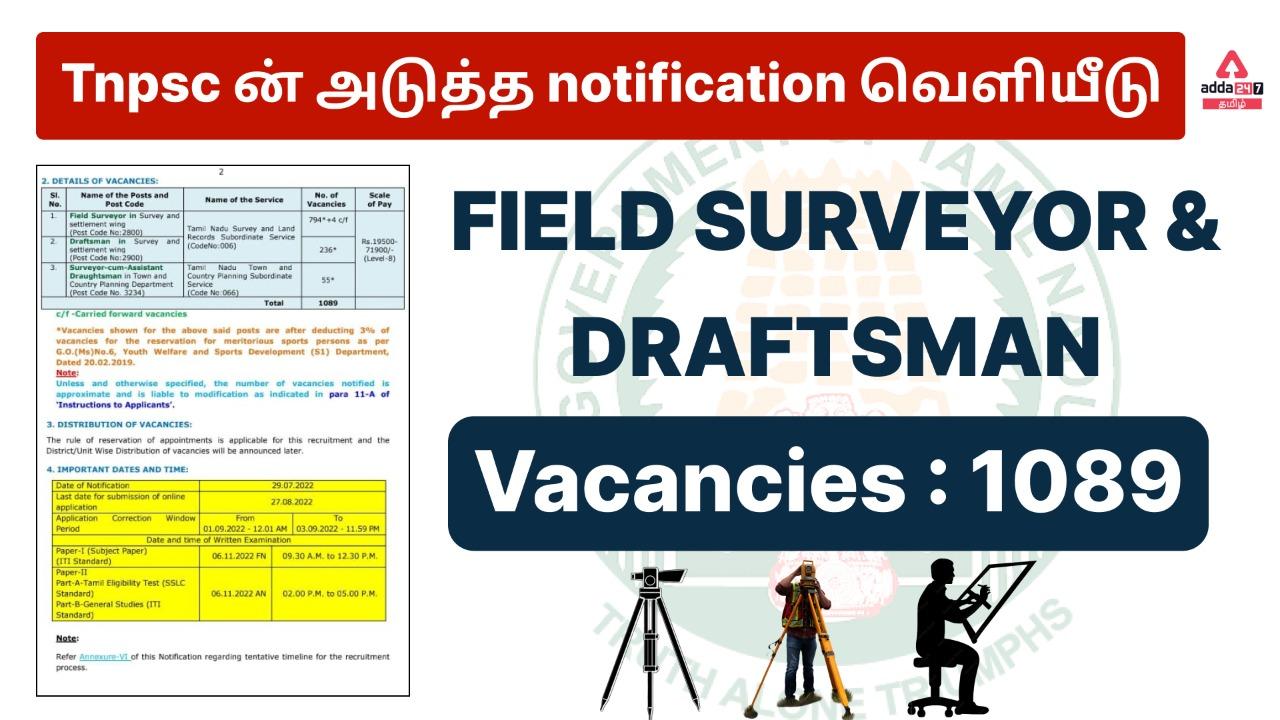
| Name of the Posts and Post Code | Name of the Service | No. of Vacancies |
| Field Surveyor in Survey and settlement wing (Post Code No:2800) | Tamil Nadu Survey and Land Records Subordinate Service (CodeNo:006) | 794*+4 c/f |
| Draftsman in Survey and settlement wing (Post Code No:2900) | 236* | |
| Surveyor-cum-Assistant Draughtsman in Town and Country Planning Department (Post Code No. 3234) | Tamil Nadu Town and Country Planning Subordinate Service (Code No:066) | 55* |
| Total | 1089 |
Read More: TNUSRB SI Exam Result 2022, Merit List & Cut Off Marks
TNPSC Field Surveyor & Draftsman Notification 2022 Qualification
| Post Name | Qualification |
| Field Surveyor |
|
| Draftsman in Survey and settlement wing |
|
| Surveyor-Assistant Draughtsman in Tamil Nadu Town and Country Planning Department |
|
TNPSC Field Surveyor & Draftsman Notification 2022 Age Limit
| Name of the Post | Maximum Age Limit | |
| “Others” [i.e., Applicants not belonging to SCs, SC(A)s, STs, MBCs/DCs, BCMs and BC(OBCMs)] | SCs, SC(A)s, STs, MBCs/DCs, BC(OBCMs) and BCMs and Destitute Widows of all categories. | |
| Field Surveyor in Survey and settlement wing | 32* Years | No Maximum age limit |
| Draftsman in Survey and settlement wing | ||
| Surveyor-cum-Assistant Draughtsman in Town and Country Planning Department | ||
| For the persons who are trained in Survey in ITI in Tamil Nadu in respect of posts of Field Surveyor and Draftsman only | 37* Years | |
TNPSC Field Surveyor & Draftsman Notification 2022 Application fee
- ஒரு முறை பதிவு செய்வதற்கான பதிவுக் கட்டணம் [G.O. (செல்வி) எண்.32, பணியாளர் மற்றும் நிர்வாக சீர்திருத்தத் துறை, தேதி 01.03.2017] 150/-
- தேர்வுக் கட்டணம் இந்த ஆட்சேர்ப்புக்கான ஆன்லைன் விண்ணப்பத்தை சமர்ப்பிக்கும் போது தேர்வுக் கட்டணம் செலுத்தப்பட வேண்டும், கட்டணம் விலக்கு கோரப்படும் வரை 100/.

TNPSC Field Surveyor & Draftsman Notification 2022 Selection Process
- எழுத்துத் தேர்வில் விண்ணப்பதாரர்கள் பெற்ற மொத்த மதிப்பெண்களின் அடிப்படையில் விண்ணப்பதாரர்கள் தேர்வு செய்யப்படும்.
- ஒரே கட்டமாக தேர்வு நடைபெறும்.
TNPSC Field Surveyor & Draftsman Notification 2022 Salary Details
இந்த 1000+ காலியிடங்களுக்கான ஊதிய அளவு ரூ.19500- 71900/- (நிலை-8) தேர்ந்தெடுக்கப்பட்ட மற்றும் நியமனம் செய்யப்பட்ட விண்ணப்பதாரர்களுக்கு.
TNPSC Field Surveyor & Draftsman Notification 2022 Apply Online
TNPSC Field Surveyor & Draftsman Notification 2022 Apply Online: தமிழ்நாடு அரசுப் பணியாளர் தேர்வாணையம், தமிழ்நாடு நில அளவையாளர் மற்றும் வரைவாளர் பணிகளுக்கான ஆட்சேர்ப்பு அறிவிப்பை வெளியிட்டுள்ளது. கீழே உள்ள லிங்க்கை கிளிக் செய்து TNPSC Field Surveyor & Draftsman பணிக்கு விண்ணப்பிக்கலாம்.
TNPSC Field Surveyor & Draftsman Notification 2022 Apply Online
How to Apply for TNPSC Field Surveyor & Draftsman Notification 2022
- விண்ணப்பதாரர்கள் ஆன்லைனில் விண்ணப்பிக்கலாம்.
- அதிகாரப்பூர்வ இணையதளத்தில் விளம்பரங்களைக் கண்டறியவும்.
- பதவிக்கு விண்ணப்பிக்கும் முன், விண்ணப்பதாரர்கள் இணையதளத்தில் பதிவு செய்ய வேண்டும்.
- எந்தத் தவறும் இல்லாமல் அனைத்து விவரங்களையும் நிரப்பவும்.
- தொடர்புடைய அனைத்து ஆவணங்களையும் இணைக்கவும்.
- ஆன்லைனில் பணம் செலுத்துங்கள்
- உங்கள் விண்ணப்பத்தை சமர்ப்பிக்கவும்.
TNPSC Field Surveyor & Draftsman Notification 2022 Exam Center
1. Chennai 0101
2. Coimbatore 0201
3. Chidambaram 0303
4 Kancheepuram 0701
5. Nagarcoil 0801
6. Madurai 1001
7. Uthagamandalam 1301
8. Pudukkottai 1501
9. Ramanathapuram 1601
10. Salem 1701
11. Karaikudi 1805
12. Thanjavur 1901
13. Tiruchirapali 2501
14. Tirunelveli 2601
15 Vellore 2701
TNPSC Field Surveyor & Draftsman Notification 2022 Exam Pattern
TNPSC Field Surveyor Notification 2022 Exam Pattern: தமிழ்நாடு அரசுப் பணியாளர் தேர்வாணையம், தமிழ்நாடு நில அளவையாளர் மற்றும் வரைவாளர் பணிகளுக்கான ஆட்சேர்ப்பு அறிவிப்பை வெளியிட்டுள்ளது. TNPSC Field Surveyor & Draftsman தேர்வு இரண்டு தாள்களாக நடைபெறும்.
| Subject | Duration | Maximum Marks | Minimum qualifying Marks for Selection | |
| SCs, SC(A)s, STs, MBC/ DCs and BCs | Others | |||
| Paper –I(Objective Type)
(Subject Paper) (200 questions) (ITI Standard) Choose any one of the following subjects
|
3 Hours | 300 | 135 | 180 |
| Paper II (Objective Type)
Part-A Tamil Eligibility Test (SSLC Standard) (100 Questions/150 Marks) |
3 Hours | Note: Minimum qualifying marks – 60 marks (40% of 150). Marks secured in Part-A of Paper-II will not be taken into account for ranking. | ||
| Part-B
General Studies (100 Questions/150 Marks) (Code: 003) General Studies (ITI Standard) (75 Questions) + Aptitude and Mental Ability Test (SSLC Standard)(25 Questions)
|
150* | |||
| Total | 450 | |||
TNPSC Field Surveyor & Draftsman Notification 2022 Syllabus
Paper-I (Objective Type) SURVEYOR (ITI STANDARD) NATIONAL TRADE CERTIFICATE
| Unit-1: Basic Engineering Drawing | Role of Surveyor: Know about the role of a surveyor – State the importance of survey. Layout of drawing sheets and title block: State the measuring of the term ‘Layout’ of drawing sheet – List the different layout styles of drawing sheets – Explain margin, frame, title block etc.Free hand sketching: State the need free hand sketching – List the situations wherein free hand sketching is useful.Drawing equipment – Drawing board, T-Square:State the construction and use of drawing boards and ‘T’ square – State the standard sizes of drawing board as per IS:1444-1989 – State the standard sizes of ‘T’ square as per IS: 1360-1989 – State the construction and uses of drafting machine – Select the pencil grades for different drawing application – Select the purpose of erasing shield – State the use of set squares in drawing work.Folding of sheets: Explain the method of folding in different size of drawing sheets. Lettering styles: Recognize different lettering styles – Designate the letters and numerals as per IS norms – State standard properties for height, width and spacing of letters. Scales: State the necessity of scales – Explain representative fraction (RF) – List the types of scales – Explain plain, Diagonal scale, comparative scale and Vernier scale. Dimensioning: Explain the types of dimensioning – Explain the elements of dimensioning – Explain the methods of indicating dimensioning – Explain the arrangement of dimensioning. Types of lines and angles: Define points and lines – State classification of lines – State the different types of angles – Explain the method of measuring angles. Triangles and their properties: Define triangles – Name the different types of triangles and state their properties. Quadrilaterals and their properties: Define a quadrilateral – Name the quadrilaterals – State the properties of quadrilaterals. Polygon and their properties: Define a Polygon – Name the Polygon in terms of the number of sides – State the properties of Polygon. |
| Unit-2: Chain Surveying | Introduction about Surveying:
Define Surveying – State the object of surveying – State technical terms – State the classification of Surveying – State the principles of Surveying – State the work of Surveyor – State the accuracy in chain Survey – State steel band Measurement of distance by a chain and chaining: State the methods of determining distance – State chaining and chaining a line – State unfolding the chain – Describe the reading the chain – State folding the chain – Calculate the errors in chaining. Introduction about chain survey instruments: State the construction and uses of the following chain survey instruments. Ranging: State ranging – State the necessity of ranging – State the types of ranging – Interpret the signals surveyor and the corresponding action by assistance. Chaining on sloping ground: Explain the methods of changing on sloping ground – State necessity of calculating horizontal distances. Offset and Offsetting: State the meaning of offset and offsetting – State the classification of offsets, its limits and its definition – State the methods of taking offsets for various site conditions. Obstacles in chain surveying: Define obstacles – State the three types of obstacles – Calculate the obstructed distance. Introduction used for setting out right angles: List out the instrument used for setting out right angles – State the types of cross staff and optical square – State the construction of cross staff and optical square – Explain the principles of optical square – State the uses of cross staff and optical square. Introduction about triangulation survey: Define the triangulation and traverse in survey – State closed and open traversed survey – State the three types of survey lines in triangulation Explain about field work. Calculation of area: Calculate the areas of an irregular field – Apply geometrical formula for calculating the area – Describe the construction and use of planimeter. |
| Unit – 3: Compass Surveying | Identification and parts of instruments in compass survey:
State about traversing – State types of compass – Name the prismatic compass and construction – Construction of surveyor’s compass Determining the bearing of a given triangular plot ABC and calculation of included angles: Calculate angles from bearings – Calculate bearing from angles. Determining the bearing of a given pentagonal plot of ABCDE and calculating included angles magnetic declination and plotting of compass survey: Calculate the angles from bearing for a closed traverse – Calculate the bearing from angles for a closed traverse – Calculate the bearing of a pentagon – Define the dip of the magnetic needles – State the magnetic declination and variations – Calculate true bearing – State local attraction and its elimination – Explain about errors and its limits – State the testing the prismatic compass. |
| Unit – 4:Plane Table Surveying | Setting up of plane table and methods of plane tabling:
State plane tabling – Name the instruments and accessories used in plane tabling – State the construction and uses of instruments accessories of plane tabling – Explain about the setting up of plane table over a station – Explain about leveling, centering and orientation in plane tabling – Explain the methods of plane tabling Methods of plane table survey: Methods of plane table survey – Radiation methods of plane table survey Intersection methods of plane table survey Traversing method of plane table survey: State traverse methods of plane table survey – Conduct traverse methods of plane table survey. Locate and plot new building by two point and three point problem: Define about resection – State two and three point problem – Describe Lehman’s rule – List out the errors in plane tabling – Describe the advantage and disadvantage Prepare a road map for 1/2 km showing details on both sides: Prepare a road map and locate the details on both sides Inking, finishing, colouring and tracing of plane table map: Explain about colouring of surveying symbols – Explain the importance of tracing – State the techniques/order of tracing a drawing – State the different types of reproduction of drawings. Minor instruments used with or without plane tabling: Explain about the construction and uses of Abney level, tangent clinometers, De Lisel’s clinometers. |
|
Unit – 5: LEVELLING & CONTOURING |
Instruments Used for Levelling:
Explain the tilting level and auto level – Explain the construction a dumpy level – Explain the classification of leveling staff. Introduction of contouring: Define contouring – Explain the terms in contouring – Narrate the characteristics of contour Topography and contour: State Topography – State contour. Tracing of grade contour: Trace the contour gradient for alignment of roads, railways, etc – Determine the volume of earth work and capacity of reservoir Computation of volume: Explain the various methods for the quantity of earth work – Compute quantity of earth work by average depth method – Compute the quantity of earth work by trapezoidal and primordial formula |
| Unit-6:THEODOLITE | Introduction to theodolite:
Explain the uses of the theodolite – Explain the classify of the theodolite – Explain the designate of the theodolite Temporary adjustment of theodolite: Set up and perform centering of the instrument – Level up the theodolite Eliminate parallax Measuring horizontal angle-repetition method: Explain the repetition method – Stage advantage of repetition method State errors which are not eliminated by repetition method. Measuring vertical angle: Define vertical angle – Differentiate angle of elevation and angle of depression – Explain how to measure vertical angle Deflection angle and direct angle: State deflection angle – Differentiate right deflection angle and left deflection angle – State the direct angle – Differentiate deflection angle and direct angle Prolonging a line: State the method for prolonging a line – Compare the method for prolonging a line – State most suitable method for prolonging a line Intersection of two straight lines: Explain method one: to find intersection point of two lines – Explain method two: to find intersection point of two lines Laying of a horizontal angle: Explain laying of a horizontal angle by ordinary method – Explain laying of a horizontal angle by repetition method – Find equivalent lenier distance for an angular value Traverse: State uses of traverse surveying – State types of traverse – Differentiate open end closed traverse Traverse checking: Explain the checks for open traverse – Explain the checks for closed traverse Classification of traverse: Classify traverse based on the instrument used – Explain method of traversing – Explain how to measure traverse length in theodolite traversing – Explain how to measure traverse angle in theodolite traversing Theodolite traversing method: State methods of theodolite surveying – Explain loose needle method – Explain fast needle method – Compare loose needle and fast needle method Theodolite traversing method II: Explain include angle method – Explain direct angle method – Explain deflection angle method – Explain azimuth method Theodolite phases: Explain theodolite traversing phases Closing error: Define closing error – Find magnitude and direction of closing error Latitudes and departures: Determine latitude – Determine departures – Balance the traverse using transit method – Balance the traverse using Bowditch’s (mathematical) method Balancing the traverse: Explain balancing the error – Describe various mathematical and graphical methods of balancing the traverse Omitted measurements: Describe omitted measurements – List out and explain the classification of omitted measurement Trigonometric levelling (indirect leveling): State advantage of indirect leveling – Explain various cases of trigonometric leveling – deduce the reduce level using the appropriate formula Introduction to curves: Explain the necessity for the provision of curves on road and railway -Explain the classification of curves – Explain the different terms used in curve Setting of horizontal curve by linear method: Determine the elements of curve – Determine the offset from long chord – Explain the method of setting cut curve by offset from long chord Setting out curves by angular methods: Determine the deflection angles of chords – Narrate the procedure of setting out of simple curve by one theodolite and tape method |
| Unit-7: TACHOMETRY | Methods of tachometry:
List the methods of tachometry – Explain the fixed hair method – Explain the movable hair method Tangential method of tachometry: Explain the tangential method of tachometry – Explain the construction of substance bar – Explain the substance method of tachometry Triangulation: Explain the term triangulation |
| Unit-8:MODERN SURVEYING INSTRUMENTS | Digital theodolite: Explain the features of the digital theodolite – Explain the difference between theodolite
and digital theodolite Total Station: Describe the features of the total station – Explain evolution of total station from the conventional equipment – Narrate the benefits of total station Remote sensing: Explain remote sensing and photogrammetry. GPS: Explain the features of global positioning system (GPS) – Narrate the use of GPS and method of surveying for accurate output – List the benefits of GPS |
| Unit-9: CADD | Introduction to cad: Explain the term CAD – Explain the use of CAD
Draw tool bar: Explain draw commands in CAD – Explain the method of drawing geometrical shapes in CAD Layers: Explain the dimensioning method in CAD – Explain the use of object snap in CAD Modifying tool bar: List out various modifying tools in CAD – Explain the uses of modifying tools in CAD Printing cad drawings: Explain the steps involved in plotting in cad |
| Unit-10: Building & Drainage | Building Drawing:
State the requirement of a good building drawing – State the method of drawing plan, elevation and typical section – State the scales used in building drawing – State Dimensioning and printing for building drawing. Drainage: State drainage and surface drainage – State four shapes of surface drainage.
|
DRAUGHTSMAN (CIVIL) (ITI STANDARD) NATIONAL TRADE CERTIFICATE
| UNIT 1: BASIC ENGINEERING DRAWING | Engineering Drawing: State the importance of engineering drawing, State the areas of civil engineering drawing. List of drawing instruments, equipments and materials to be used during
training: State instruments, equipments and materials, List out instruments, equipments and materials, State the standard as per 962-1987, To use different drawing instruments, equipments and materials, Follow precautions in the use of instruments, equipments and materials. Layout of drawing Sheet: State the system of layout of drawing sheet, List the different layout for designated drawing sheet Explain the title block. Folding of drawing Sheet: State the purpose of folding a drawing sheet, Explain the method of folding for drawing sheet |
| UNIT 2: GEOMETRICAL CONSTRUCTION | Plane Geometrical construction: Define the terms of most commonly used geometrical shapes
Types of Lines and Angles: Define points and lines, State the classification of lines, State the different types of angles, Explain the method of measuring angles. Triangles and their types: Define triangles, Name the different types of triangles and state their properties. Quadrilaterals and their properties: Define a quadrilateral, Name the quadrilaterals, State the properties of quadrilaterals Polygon and their properties: Define Polygon, Name the Polygon in terms of the number of sides, State the properties of polygon. |
| UNIT 3: CHAIN SURVEYING | Introduction – History and principles of chain survey and instrument & employed: Define surveying, Explain the classification of Surveying, Narrate different methods of measurements, Express the instruments used for chain surveying.
Introduction about chain survey instruments: State the construction and uses of the chain survey instruments Testing of metric chain (20m/30m): State the necessity of checking the chain, State the methods of testing, List out then errors in the chain, State the limits of error in chain, Explain the adjust the chain, State Indian optical square Measurement of distance by chain and chaining: State chaining and chaining a line, State unfolding the chain, Describe the reading the chain, State folding the chain, Calculate the errors in chaining |
| UNIT 4: COMPASS SURVEYING | Identification and parts of instruments in compass survey: State about traversing, State types of compass, Name the prismatic compass and construction, Construction of survey’s compass
Determining the bearing of a given triangular plot of ABC and calculation of included angles: Calculate angles from bearing, Calculate bearing from angles Determining the bearing of a given pentagonal plot of ABCDE and calculation of included angles: Calculate angles from bearings for a closed traverse, Calculate bearing from angles for a closed traverse, Calculate bearing of a pentagon Magnetic declination and local attraction: Define the dip of the Magnetic needles, State the magnetic declination and variations, Calculate true Bearing, State local attraction and its elimination, Explain about errors and limits, State the testing the prismatic compass |
| UNIT 5: PLANE TABLE SURVEYING | Instrument used in plane table surveying: State plane tabling, Name the instruments and accessories used in plan tabling, State the construction and uses of instruments and accessories used in plan tabling, Explain about leveling, centering and orientation in plain tabling, Explain the methods of plain tabling
Resection method of plane table survey: State the resection method of plane table survey |
| UNIT 6: LEVELLING | Types of levelling: Name the various types of levelling, Explain simple levelling, Explain differential levelling, Complete the reduced levels of points. |
| UNIT 7: ROAD ENGINEERING – I | Introduction to road engineering: Define road, Define highway engineering, Define necessity and characteristics of Road
Technical term used in road engineering: Define road and Total Station advantage, Define various terms used in road engineering, Describe the various advantages of road Principle of road alignment: Alignment of road, Express the principle of highway alignment, Explain the different survey required for alignment Classification of roads: Describe the different classification of roads |
| UNIT 8: ROAD ENGINEERING II | Road Margins: Define road margin, Describe the element Total Station of road margin
Camber, super elevation, sight distance and gradient: Define camber, Explain super elevation, sight distance and express gradient |
| UNIT 9: TOTAL STATION | Introduction to total station: Get introduced to the Total station, Learn the evaluation of Total station from the convectional equipmen Total Station, Explain the benefit Total Station and uses of Total station
Types of total station: Explain the advantages and disadvantages of Total station, Explain the types of Total Station, Explain the precautions to be taken while using Total Station Measurement with total station: Explain the equipment required for Total Station surveying, Explain the procedure of measurement with Total Station Characteristics and features of total station: Define the features of Total Station, State the characteristics of Total Station, Advantages and disadvantages of Total Station Principle of EDM- Working need setting and measurement Total Station: Define EDM, State the principle of EDM, Features of EDM Setting and measurement Total Station: Define distance measuring, State principal of EDM, State classification of EDM Total station Prism- instrument error operation: Explain Total Station prisms, Describe sources of error in EDM,EDM instrument operation, Uses of EDM Electronic display and data recording: Define electronic data recording, Explain field computers, Define recording module, Internal memories Rectangular and Polar Co-ordinate system: Illustrate rectangular and polar coordinates |
| UNIT 10: GLOBAL POSITIONING SYSTEM | Introduction of GPS: Explain GPS coordinate system, Describe Geographic latitude and longitude, GPS equipment
Satellite and Conventional Geodetic system: What is satellite system, Define Geodetic system GPS coordinate system and component Total Station of GPS & System segment Total Station: Explain GPS coordinate system, Describe Geographic Latitude and Longitude, Explain and describe component Total Station GPS receiver GPS segment Total Station: Define GPS segment Principle of Operation of GPS and surveying with GPS: State the Principle of Operation of GPS, Describe the role of transit in GPS Remote sensing: Explain Remote sensing, Distinguish between GPS, GIS and Total Station GPS signal code – GPS basics: Introduction to digital signal, Explain data acquisition system, Describe signal processing, Explain code an basics |
Paper – II Part A Tamil Eligibility Test
- பிரித்தெழுதுதல்/சேர்த்தெழுதுதல்.
- எதிர்ச்சொல்லை எடுத்தெழுதுதல்.
- பொருந்தாச்சொல்லைக் கண்டறிதல்
- பிழை திருத்தம் (i) சந்திப்பிழையை நீக்குதல் ( ii) மரபுப் பிழைகள், வழுவுச் சொற்களை நீக்குதல் பிறமொழிச்சொற்களை நீக்குதல்
- ஆங்கிலச்சொல்லுக்கு நேரான தமிழ்ச்சொல்லை அறிதல்.
- ஒலி மற்றும் பொருள் வேறுபாடறிந்து சரியான பொருளையறிதல்.
- ஒரு பொருள் தரும் பல சொற்கள்.
- வேர்ச்சொல்லைத் தேர்வு செய்தல்.
- வேர்ச்சொல்லைக் கொடுத்து வினைமுற்று, வினையெச்சம், வினையாலணையும் பெயர், தொழிற்பெயரை உருவாக்கல்
- அகரவரிசைப்படி சொற்களை சீர் செய்தல்.
- சொற்களை ஒழுங்குப்படுத்தி சொற்றொடராக்குதல்.
- இருவினைகளின்பொருள் வேறுபாடு அறிதல் (எ.கா.) குவிந்து குவித்து
- விடைக்கேற்ற வினாவைத்தேர்ந்தெடுத்தல்.
- எவ்வகை வாக்கியம் என க்கண்டெழுதுதல் – தன்வினை, பிறவினை, செய்வினை, செயப்பாட்டு வினைவாக்கியங்களைக் கண்டெழுதுதல்.
- உவமையால் விளக்கப்பெறும் பொருத்தமான பொருளைத்தேர்ந்தெழுதுதல்
- அலுவல்சார்ந்தசொற்கள் (கலைச்சொல்)
- விடைவகைகள்
- பிறமொழிச் சொற்களுக்கு இணையான தமிழ்ச் சொற்களைக் கண்டறிதல் (எ.கா.) கோல்டுபிஸ்கட்-தங்கக்கட்டி
- ஊர்ப்பெயர்களின்மரூஉவை எழுதுக (எ.கா.) தஞ்சாவூர்-தஞ்சை
- நிறுத்தற்குறிகளை அறிதல்
- பேச்சுவழக்கு, எழுத்து வழக்கு வாரான்-வருகிறான்).
- சொற்களை இணைத்து புதிய சொல் உருவாக்கல்
- பொருத்தமானகாலம் அமைத்தல் (இறந்தகாலம், நிகழ்காலம், எதிர்காலம்).
- சரியான வினாச்சொல்லைத் தேர்ந்தெடு
- சரியான இணைப்புச் சொல் (எனவே, ஏனெனில், ஆகையால், அதனால், அதுபோல).
- அடைப்புக்குள் உள்ள சொல்லைத் தகுந்த இடத்தில் சேர்க்க.
- இருபொருள்தருக.
- குறில் நெடில் மாற்றம், பொருள்வேறுபாடு
- கூற்று காரணம் சரியா? தவறா?
- கலைச்சொற்களை அறிதல் எ.கா.- Artificial Intelligence – செயற்கை நுண்ண றிவு Super Computer -மீத்திறன் கணினி
- பொருத்தமானபொருளைத் தெரிவு செய்தல்
- சொற்களின் கூட்டுப்பெயர்கள் (எ.கா.) புல் புற்கள்
- சரியான தொடரைத்தேர்ந்தெடுத்தல்
- பிழைதிருத்துதல் ஒரு.ஓர்)
- சொல்-பொருள் பொருத்துக
- ஒருமை-பன்மை பிழை
- பத்தியிலிருந்து வினாவிற்கான சரியான விடையைத் தேர்ந்தெடு
Read More: TNPSC Result Date Schedule 2022
Paper – II – Part-B – General Studies (ITI Standard)
| Name of Subject | Topics |
| General Science |
|
| Current Events |
|
|
Geography of India |
|
| History and Culture of India |
|
| Indian Polity |
|
| Indian Economy |
|
| Indian National Movement |
|
| History, Culture, Heritage and Socio-Political Movements in Tamil Nadu |
(a) Significance as Secular literature. (b) Relevance to Everyday Life (c) Impact of Thirukkural on Humanity (d) Thirukkural and Universal Values – Equality, Humanism, etc (e) Relevance to Socio -Politico-Economic affairs (f) Philosophical content in Thirukkural
|
| Development Administration in Tamil Nadu |
|
| Aptitude and Mental Ability |
|
TNPSC Field Surveyor & Draftsman Notification 2022 Important Dates
| Notification Date | 29.07.2022 |
| Last date for submission of application | 27.08.2022 |
| Application correction period | From 01.09.2022 to 03.09.2022 |
| Date of examination (Paper-I) | 06.11.2022 (FN) Time: 9.30-12.30PM |
| (Paper-II) | 06.11.2022 (FN) Time: 2.00-05.00PM |
இது போன்ற தேர்விற்கான தகவல் மற்றும் பாடக்குறிப்புகளை பெற ADDA247 தமிழ் செயலியை பதிவிறக்கம் செய்யுங்கள்
To Attempt the Quiz on APP with Timings & All India Rank,
Download the app now, Click here
Adda247 பயன்பாட்டில் இந்த வினாடி வினாவை முயற்சிக்க இங்கே கிளிக் செய்து அகில இந்திய தரவரிசையைப் பெறுங்கள்
| Adda247 TamilNadu Home page | Click here |
| Official Website=Adda247 | Click here |
Use Code: MN15 (15% OFF ON ALL )
-
-

- MADRAS HIGH COURT | Complete Classes For All Posts | Tamil | Online Live Classes By Adda247
-
***************************************************************************
*இப்போது உங்கள் வீட்டில் தமிழில் நேரடி வகுப்புகள் கிடைக்கின்றன*
*பயிற்சி மட்டுமே தேர்வுர உங்களுக்கு உதவ முடியும் | Adda247 தமிழ் மூலம் உங்கள் பயிற்சியை இப்போது தொடங்கவும்*
Adda247App | Adda247 Tamil Youtube
Tamil Engineering Classes by Adda247 Youtube link
Adda247 Tamil telegram group –Tnpsc sure shot selection group
Instagram = Adda247 Tamil