


Correct option is C
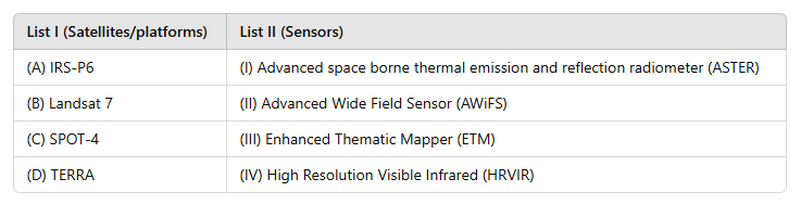
The correct answer is (c) A-II, B-III, C-IV, D-I because the satellites and their corresponding sensors are as follows:
1. (A) IRS-P6 → (II) Advanced Wide Field Sensor (AWiFS)
2. (B) Landsat 7 → (III) Enhanced Thematic Mapper (ETM)
3. (C) SPOT-4 → (IV) High Resolution Visible Infrared (HRVIR)
4. (D) TERRA → (I) Advanced Spaceborne Thermal Emission and Reflection Radiometer (ASTER)
Information Booster: 1. IRS-P6: Part of the Indian Remote Sensing satellite series, equipped with the Advanced Wide Field Sensor (AWiFS) for agricultural and resource management.
2. Landsat 7: A US satellite in the Landsat program, featuring the Enhanced Thematic Mapper (ETM) for land cover analysis.
3. SPOT-4: French satellite with the High Resolution Visible Infrared (HRVIR) sensor for detailed imaging.
4. TERRA: A NASA satellite carrying the ASTER sensor, which provides high-resolution thermal and reflection data for Earth science.
Additional Knowledge: · AWiFS (Advanced Wide Field Sensor): Provides wide-area coverage with moderate resolution, used in environmental monitoring.
· ETM (Enhanced Thematic Mapper): Offers multi-spectral and thermal imaging, valuable for land and resource analysis.
· HRVIR (High Resolution Visible Infrared): High-resolution optical and near-infrared imaging sensor, useful for topography.
· ASTER (Advanced Spaceborne Thermal Emission and Reflection Radiometer): Captures high-resolution thermal and reflective data, ideal for studying the Earth's surface.
 English
 10 Questions
 20 Marks
 12 Mins
