
Table of Contents
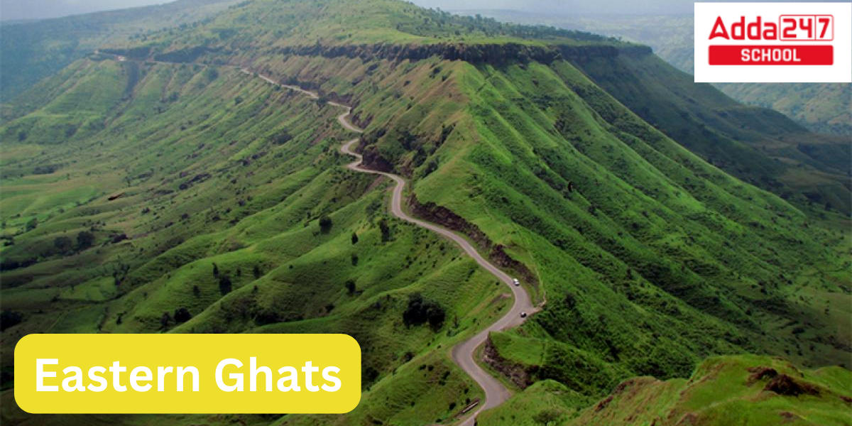
Eastern Ghats
Along India’s eastern coast, there is a disjointed mountain range known as the Eastern Ghats. The Eastern Ghats travel across Odisha, Andhra Pradesh, and Telangana before ending in Tamil Nadu in the south. The Mahanadi, Godavari, Krishna, and Kaveri are the four principal rivers of peninsular India that erode and cut through them.
- The highest point in Odisha is Deomali, which is 1672 metres high.
- With a height of 1680 metres, Arma Konda/Jindhagada Peak is Andhra Pradesh’s highest point.
- The BR hill range in Karnataka is the tallest in the Eastern Ghats, with many of its peaks rising beyond 1750 metres.
- The tallest mountain in the Eastern Ghats is Kattahi Betta in the BR Hills, standing at 1822 metres.
- The second tallest hill range in Tamil Nadu is Thalamalai.
- The third tallest hill range is the Araku range.
Eastern Ghat Biodiversity
The Jerdon’s courser (Rhinoptilus bitorquatus) and grey slender loris are two examples of the indigenous fauna of the Eastern Ghats (Loris lydekkerianus). There are several rare geckos that can be found in this area, including the Indian golden gecko (Calodactylodes aureus), the granite rock gecko (Hemidactylus graniticolus), the Yercaud slender gecko (Hemiphyllodactylus aurantiacus),[9] other lizards like Sharma’s skink (Eutropis nagarjuni), and snake (Coluber bholanathi).
Neighbouring Countries of India, with Map and Their Capitals
Eastern Ghats Geology
Charnockites, granite gneisses, khondalites, metamorphic gneisses, and quartzite rock formations make up the Eastern Ghats. Strike-slip faults and thrusts are both present in the Eastern Ghats’ structural makeup across its whole length. The Eastern Ghats mountain ranges are home to deposits of limestone, bauxite, and iron ore.
The Tirumala Hills’ Eparchaean Unconformity is a significant stratigraphic discontinuity that marks a protracted era of erosion and non-deposition. The Tirumala ghat roads in the Tirupati district of Andhra Pradesh include steep natural slopes, road scars, and ravines where it may be observed.
Western Ghats Biodiversity, States, Mountain and Highest Peak
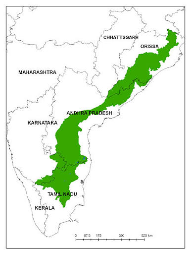
Eastern Ghats States
- The states in which Eastern Ghats lies include Odisha, Andhra Pradesh, Tamil Nadu, Karnataka and Telangana.
- The Eastern Ghats straddle the Coromandal between latitudes of 11° 30′ and 22° N and longitudes of 76° 50′ to 86° 30′ E, covering an area of around 75,000 square kilometres.
- Its northern and southern boundaries are the river basins of the Mahanandi and Cauvery, respectively.
- To the west are the uplands of Tamil Nadu and the apexes of the Bastar, Telangana, and Karnataka plateaus.
- The Eastern Coastal region limits its easternmost part.
- The Eastern Ghats extend from northern Odisha to Andhra Pradesh and Telangana to southern Tamil Nadu, passing through parts of Karnataka.
The highest peak of western ghats in India- Cardamom hills
Eastern Ghats in India Map

Eastern Ghats Rivers
Many of the small and medium-sized rivers that flow into South India’s eastern coastal plains originate in the Eastern Ghats.
| Rivers flowing through the Eastern Ghats | Rivers originating on the Eastern Ghats |
|
|
Highest Peak of Eastern Ghats
The highest peak of eastern ghats are an uneven range of mountains that extends from Eastern India to Southern India. Each location has a unique name for this mountain range. The eastern ghats highest peak alone is 1,690 metres high. It is a mountain range with gaps in it. Mahanadi, Godavari, Krishna, and Kaveri are its four principal Indian rivers.
Jindhagada Peak is the highest peak of eastern ghats. In addition to being the highest mountain peak in the Eastern Ghats, Jindhagada Peak is also thought to have the greatest elevation of any mountain peak in the state of Andhra Pradesh. This Easter Ghat peak, which is situated in Andhra Pradesh’s Araku Valley, was originally uncovered in 2011. eastern ghats highest peak ghats was found in April 2011 by a team under the direction of Mr. Venkat Reddy.
The highest peak in the Eastern Ghats is Jindhagada Peak
Ghats Meaning
The term “ghats” can have different meanings depending on the context:
Geographical Context: In the context of geography, “ghats” refers to a series of steps or a long, continuous flight of steps leading down to a body of water, typically a river. These steps are often used for various purposes, such as bathing, religious rituals, and access to water. The term is commonly associated with the “ghats” along the banks of the Ganges River in India, where people gather for religious ceremonies and ablutions.
Mountain Ranges: In India, the term “ghats” can also refer to the Western Ghats and the Eastern Ghats, which are two mountain ranges that run parallel to the western and eastern coasts of India, respectively. These mountain ranges are known for their rich biodiversity and are important geographical features of the Indian subcontinent.
Colloquial Usage: In some contexts, “ghats” might be used colloquially to refer to hilly or elevated terrain, especially in South Asia.
Surname: “Ghats” can also be a surname in some cultures or regions.
The meaning of “ghats” will depend on the specific context in which it is used.
 JAC 11th Result 2024 Releasing on this D...
 TN 11th Result 2024 to be Announced on M...
 VITEEE Sample Paper 2024, Download Subje...